Räpina geodata
Räpina (Põlvamaa) is a seat of a second-order administrative division; located in Estonia in Europe/Tallinn (GMT+3) time zone. With population of 2,901 people, there are 37 cities with bigger population in this country. Compared to other cities in Estonia, 88.9% of cities are located further ↑North; 96.3% of cities are located further ←West and 64.7% of cities have higher elevation than Räpina. Note1


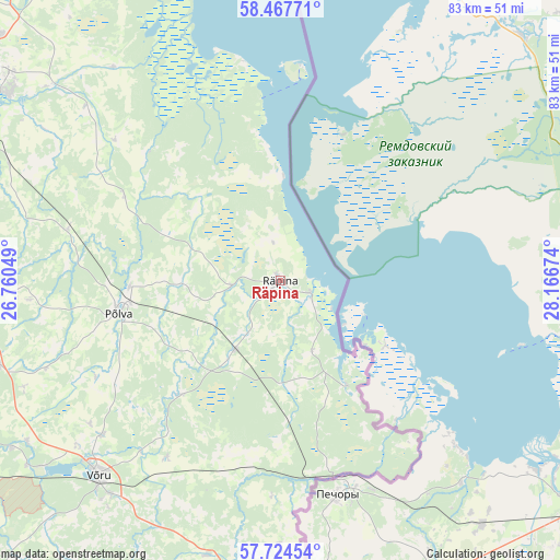
Räpina GPS coordinates[2]
58° 5' 53.016" North, 27° 27' 48.996" East
| Map corner | latitude | longitude |
|---|---|---|
| Upper-left | 58.46771°, | 26.76049° |
| Center: | 58.09806°, | 27.46361° |
| Lower-right: | 57.72454°, | 28.16674° |
| Map W x H: | 82.6×82.6 km | = 51.3×51.3mi |
| max Lat: | 59.57639° ⇑88.9% North |
| Räpina: | 58.09806° |
| min Lat: | ⇓11.1% South 57.72778° |
| min Long | Räpina | max Long |
| 22.24646° | 27.46361° | 28.19028° |
| W 96.3%⇐ | ⇒3.7% E |
Elevation
Elevation of Räpina is 43 m = 141 ft, and this is 10.2 m = 33 ft below average elevation for this country.
| Max E: |
141 m = 463 ft | 64.7% |
| Avg. | 53.2 m = 175 ft | |
| Räpina | 43 m = 141 ft | |
Min E: |
6 m = 20 ft | 35.3% |
See also: Estonia elevation on elevation.city.
Geographical zone
Räpina is located in North temperate zone (between Tropic of Cancer and the Arctic Circle). Distance of this North polar circle is 941.3 km =584.9 mi to North.| Distance of | km | miles | from Räpina |
|---|---|---|---|
| North Pole | 3547.2 | 2204.1 | to North |
| Arctic Circle | 941.3 | 584.9 | to North |
| Tropic Cancer | 3854 | 2394.8 | to South |
| Equator | 6459.9 | 4014 | to South |


Nearby cities:
15 places around Räpina: (largest is in red/bold)
• Ahja
25.7 km =16 mi,  297°
297°
• Himmaste
23 km =14.3 mi,  264°
264°
• Kanepi
43.5 km =27 mi,  252°
252°
• Kose
40.5 km =25.2 mi,  218°
218°
• Kurepalu
44 km =27.3 mi, 303°
• Mammaste
24.8 km =15.4 mi, 261°
• Parksepa
35.2 km =21.9 mi,  233°
233°
• Põlva
23.6 km =14.7 mi, 259°
• Vastse-Kuuste
32.3 km =20.1 mi,  283°
283°
• Vastseliina
42.2 km =26.2 mi,  193°
193°
• Veriora
12.3 km =7.6 mi,  212°
212°
• Väimela
34.9 km =21.7 mi, 228°
• Värska
18.6 km =11.6 mi,  146°
146°
• Võnnu
31.5 km =19.6 mi,  309°
309°
• Võru
39.4 km =24.5 mi, 221°
Sources, notices
• [Note1] Compared only with cities in Estonia existing in our database
• [Src1] Map data: © OpenStreetMap contributors (CC-BY-SA)
• [Src2] Other city data from geonames.org with taken over terms of usage.
• [Src3] Geographical zone / Annual Mean Temperature by Robert A. Rohde @ Wikipedia
