Būsh geodata
Būsh (Beni Suweif) is a populated place; located in Egypt in Africa/Cairo (GMT+2) time zone. With population of 86,608 people, there are 44 cities with bigger population in this country. Compared to other cities in Egypt, 63.8% of cities are located further ↑North; 64.5% of cities are located further →East and 69.6% of cities have lower elevation than Būsh. Note1


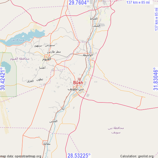
Būsh GPS coordinates[2]
29° 8' 53.376" North, 31° 7' 38.388" East
| Map corner | latitude | longitude |
|---|---|---|
| Upper-left | 29.7604°, | 30.42421° |
| Center: | 29.14816°, | 31.12733° |
| Lower-right: | 28.53225°, | 31.83046° |
| Map W x H: | 136.6×136.6 km | = 84.9×84.9mi |
| max Lat: | 31.5084° ⇑63.8% North |
| Būsh: | 29.14816° |
| min Lat: | ⇓36.2% South 22.3457° |
| min Long | Būsh | max Long |
| 25.51965° | 31.12733° | 34.89572° |
| W 35.5%⇐ | ⇒64.5% E |
Elevation
Elevation of Būsh is 31 m = 102 ft, and this is 12.5 m = 41 ft below average elevation for this country.
| Max E: |
1565 m = 5135 ft | 30.4% |
| Avg. | 43.5 m = 143 ft | |
| Būsh | 31 m = 102 ft | |
Min E: |
-15 m = -49 ft | 69.6% |
See also: Būsh elevation on elevation.city.
Geographical zone
Būsh is located in North temperate zone (between Tropic of Cancer and the Arctic Circle). Distance of this Northern Tropic circle is 635.1 km =394.6 mi to South.| Distance of | km | miles | from Būsh |
|---|---|---|---|
| North Pole | 6766.1 | 4204.3 | to North |
| Arctic Circle | 4160.2 | 2585 | to North |
| Tropic Cancer | 635.1 | 394.6 | to South |
| Equator | 3241 | 2013.9 | to South |


Nearby cities:
15 places around Būsh: (largest is in red/bold)
• Al Fashn
42.3 km =26.3 mi,  211°
211°
• Al Fayyūm
33 km =20.5 mi,  302°
302°
• Al Wāsiţah
22.4 km =13.9 mi,  19°
19°
• Al Ḩawāmidīyah
84.4 km =52.4 mi,  8°
8°
• Al ‘Ayyāţ
53.9 km =33.5 mi, 13°
• Aş Şaff
48.7 km =30.3 mi, 17°
• Banī Mazār
78.4 km =48.7 mi,  203°
203°
• Banī Suwayf
8.7 km =5.4 mi, 199°
• Ibshawāy
49.3 km =30.6 mi, 298°
• Iţsā
34.3 km =21.3 mi,  286°
286°
• Madīnat Sittah Uktūbar
74.7 km =46.4 mi,  354°
354°
• Maţāy
87.9 km =54.6 mi, 202°
• Sumusţā as Sulţānī
37.3 km =23.2 mi,  226°
226°
• Ţāmiyah
39.9 km =24.8 mi,  336°
336°
• Ḩalwān
78.9 km =49 mi, 12°
Sources, notices
• [Note1] Compared only with cities in Egypt existing in our database
• [Src1] Map data: © OpenStreetMap contributors (CC-BY-SA)
• [Src2] Other city data from geonames.org with taken over terms of usage.
• [Src3] Geographical zone / Annual Mean Temperature by Robert A. Rohde @ Wikipedia
