Maţāy geodata
Maţāy (Minya) is a populated place; located in Egypt in Africa/Cairo (GMT+2) time zone. With population of 45,215 people, there are 95 cities with bigger population in this country. Compared to other cities in Egypt, 69.6% of cities are located further ↑North; 84.1% of cities are located further →East and 72.5% of cities have lower elevation than Maţāy. Note1


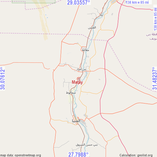
Maţāy GPS coordinates[2]
28° 25' 8.364" North, 30° 46' 45.264" East
| Map corner | latitude | longitude |
|---|---|---|
| Upper-left | 29.03557°, | 30.07612° |
| Center: | 28.41899°, | 30.77924° |
| Lower-right: | 27.7988°, | 31.48237° |
| Map W x H: | 137.5×137.5 km | = 85.4×85.4mi |
| max Lat: | 31.5084° ⇑69.6% North |
| Maţāy: | 28.41899° |
| min Lat: | ⇓30.4% South 22.3457° |
| min Long | Maţāy | max Long |
| 25.51965° | 30.77924° | 34.89572° |
| W 15.9%⇐ | ⇒84.1% E |
Elevation
Elevation of Maţāy is 40 m = 131 ft, and this is 3.5 m = 11 ft below average elevation for this country.
| Max E: |
1565 m = 5135 ft | 27.5% |
| Avg. | 43.5 m = 143 ft | |
| Maţāy | 40 m = 131 ft | |
Min E: |
-15 m = -49 ft | 72.5% |
See also: Maţāy elevation on elevation.city.
Geographical zone
Maţāy is located in North temperate zone (between Tropic of Cancer and the Arctic Circle). Distance of this Northern Tropic circle is 554 km =344.2 mi to South.| Distance of | km | miles | from Maţāy |
|---|---|---|---|
| North Pole | 6847.2 | 4254.7 | to North |
| Arctic Circle | 4241.3 | 2635.4 | to North |
| Tropic Cancer | 554 | 344.2 | to South |
| Equator | 3159.9 | 1963.5 | to South |


Nearby cities:
15 places around Maţāy: (largest is in red/bold)
• Abū Qurqāş
54.5 km =33.9 mi,  173°
173°
• Al Fashn
46.6 km =29 mi,  14°
14°
• Al Fayyūm
99.3 km =61.7 mi,  3°
3°
• Al Minyā
34.5 km =21.4 mi,  184°
184°
• Al Qūşīyah
108.9 km =67.7 mi, 177°
• Banī Mazār
9.6 km =6 mi, 12°
• Banī Suwayf
79.2 km =49.2 mi,  23°
23°
• Būsh
87.9 km =54.6 mi, 22°
• Dayr Mawās
86.7 km =53.9 mi, 175°
• Dayrūţ
96 km =59.7 mi, 178°
• Ibshawāy
105 km =65.2 mi,  354°
354°
• Iţsā
91 km =56.5 mi, 0°
• Mallawī
76.7 km =47.7 mi, 175°
• Samālūţ
13.7 km =8.5 mi,  209°
209°
• Sumusţā as Sulţānī
55.8 km =34.7 mi, 7°
Sources, notices
• [Note1] Compared only with cities in Egypt existing in our database
• [Src1] Map data: © OpenStreetMap contributors (CC-BY-SA)
• [Src2] Other city data from geonames.org with taken over terms of usage.
• [Src3] Geographical zone / Annual Mean Temperature by Robert A. Rohde @ Wikipedia
