Villarrubio geodata
Villarrubio (Castille-La Mancha) is a seat of a third-order administrative division; located in Spain in Europe/Madrid (GMT+2) time zone. With population of 254 people, there are 4719 cities with bigger population in this country. Compared to other cities in Spain, 71.1% of cities are located further ↑North; 56% of cities are located further ←West and 72.3% of cities have lower elevation than Villarrubio. Note1
Administrative division(s):
- Level 1: Castille-La Mancha
- Level 2: Provincia de Cuenca
- Level 3: Villarrubio


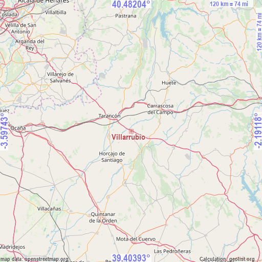
Villarrubio GPS coordinates[2]
39° 56' 42.396" North, 2° 53' 39.516" West
| Map corner | latitude | longitude |
|---|---|---|
| Upper-left | 40.48204°, | -3.59743° |
| Center: | 39.94511°, | -2.89431° |
| Lower-right: | 39.40393°, | -2.19118° |
| Map W x H: | 119.9×119.9 km | = 74.5×74.5mi |
| max Lat: | 43.74134° ⇑71.1% North |
| Villarrubio: | 39.94511° |
| min Lat: | ⇓28.9% South 27.64134° |
| min Long | Villarrubio | max Long |
| -18.00367° | -2.89431° | 4.2899° |
| W 56%⇐ | ⇒44% E |
Elevation
Elevation of Villarrubio is 829 m = 2720 ft, and this is 231 m = 758 ft above average elevation for this country.
| Max E: |
1682 m = 5518 ft | 27.7% |
| Villarrubio | 829 m 2720 ft | |
| Avg. | 598 m = 1962 ft | |
Min E: |
0 m = 0 ft | 72.3% |
See also: Spain elevation on elevation.city.
Geographical zone
Villarrubio is located in North temperate zone (between Tropic of Cancer and the Arctic Circle). Distance of this Northern Tropic circle is 1835.6 km =1140.6 mi to South.| Distance of | km | miles | from Villarrubio |
|---|---|---|---|
| North Pole | 5565.6 | 3458.3 | to North |
| Arctic Circle | 2959.7 | 1839.1 | to North |
| Tropic Cancer | 1835.6 | 1140.6 | to South |
| Equator | 4441.5 | 2759.8 | to South |


Nearby cities:
15 places around Villarrubio: (largest is in red/bold)
• Alcázar del Rey
15 km =9.3 mi,  29°
29°
• Almonacid del Marquesado
17.3 km =10.7 mi,  141°
141°
• Belinchón
17.7 km =11 mi,  309°
309°
• Fuente de Pedro Naharro
10.1 km =6.3 mi,  256°
256°
• Horcajo de Santiago
14.4 km =8.9 mi,  217°
217°
• Huelves
10.9 km =6.8 mi,  4°
4°
• Paredes
13.8 km =8.6 mi,  14°
14°
• Pozorrubio
15.1 km =9.4 mi,  198°
198°
• Puebla de Almenara
19.1 km =11.9 mi,  159°
159°
• Rozalén del Monte
9.1 km =5.7 mi,  56°
56°
• Saelices
8.1 km =5 mi,  109°
109°
• Tarancón
11.9 km =7.4 mi, 306°
• Torrubia del Campo
7.8 km =4.8 mi,  227°
227°
• Tribaldos
3.1 km =1.9 mi,  353°
353°
• Uclés
4.7 km =2.9 mi,  36°
36°
Sources, notices
• [Note1] Compared only with cities in Spain existing in our database
• [Src1] Map data: © OpenStreetMap contributors (CC-BY-SA)
• [Src2] Other city data from geonames.org with taken over terms of usage.
• [Src3] Geographical zone / Annual Mean Temperature by Robert A. Rohde @ Wikipedia
