Huelves geodata
Huelves (Castille-La Mancha) is a seat of a third-order administrative division; located in Spain in Europe/Madrid (GMT+2) time zone. With population of 57 people, there are 6380 cities with bigger population in this country. Compared to other cities in Spain, 69.7% of cities are located further ↑North; 56.2% of cities are located further ←West and 71.2% of cities have lower elevation than Huelves. Note1
Administrative division(s):
- Level 1: Castille-La Mancha
- Level 2: Provincia de Cuenca
- Level 3: Huelves


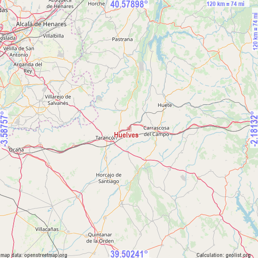
Huelves GPS coordinates[2]
40° 2' 34.152" North, 2° 53' 3.984" West
| Map corner | latitude | longitude |
|---|---|---|
| Upper-left | 40.57898°, | -3.58757° |
| Center: | 40.04282°, | -2.88444° |
| Lower-right: | 39.50241°, | -2.18132° |
| Map W x H: | 119.7×119.7 km | = 74.4×74.4mi |
| max Lat: | 43.74134° ⇑69.7% North |
| Huelves: | 40.04282° |
| min Lat: | ⇓30.3% South 27.64134° |
| min Long | Huelves | max Long |
| -18.00367° | -2.88444° | 4.2899° |
| W 56.2%⇐ | ⇒43.8% E |
Elevation
Elevation of Huelves is 822 m = 2697 ft, and this is 224 m = 735 ft above average elevation for this country.
| Max E: |
1682 m = 5518 ft | 28.8% |
| Huelves | 822 m 2697 ft | |
| Avg. | 598 m = 1962 ft | |
Min E: |
0 m = 0 ft | 71.2% |
See also: Spain elevation on elevation.city.
Geographical zone
Huelves is located in North temperate zone (between Tropic of Cancer and the Arctic Circle). Distance of this Northern Tropic circle is 1846.4 km =1147.3 mi to South.| Distance of | km | miles | from Huelves |
|---|---|---|---|
| North Pole | 5554.7 | 3451.5 | to North |
| Arctic Circle | 2948.8 | 1832.3 | to North |
| Tropic Cancer | 1846.4 | 1147.3 | to South |
| Equator | 4452.3 | 2766.5 | to South |


Nearby cities:
15 places around Huelves: (largest is in red/bold)
• Alcázar del Rey
6.9 km =4.3 mi,  71°
71°
• Barajas de Melo
9.4 km =5.8 mi,  342°
342°
• Belinchón
14.5 km =9 mi,  271°
271°
• Fuente de Pedro Naharro
16.9 km =10.5 mi,  218°
218°
• Illana
15.9 km =9.9 mi,  352°
352°
• Leganiel
14.7 km =9.1 mi, 337°
• Paredes
3.6 km =2.2 mi,  45°
45°
• Rozalén del Monte
8.9 km =5.5 mi,  130°
130°
• Saceda-Trasierra
12.8 km =8 mi,  11°
11°
• Saelices
15.2 km =9.4 mi,  153°
153°
• Tarancón
11.1 km =6.9 mi,  249°
249°
• Tribaldos
7.9 km =4.9 mi,  188°
188°
• Uclés
7.3 km =4.5 mi,  164°
164°
• Vellisca
11.3 km =7 mi,  31°
31°
• Villarrubio
10.9 km =6.8 mi,  184°
184°
Sources, notices
• [Note1] Compared only with cities in Spain existing in our database
• [Src1] Map data: © OpenStreetMap contributors (CC-BY-SA)
• [Src2] Other city data from geonames.org with taken over terms of usage.
• [Src3] Geographical zone / Annual Mean Temperature by Robert A. Rohde @ Wikipedia
