Alcázar del Rey geodata
Alcázar del Rey (Castille-La Mancha) is a seat of a third-order administrative division; located in Spain in Europe/Madrid (GMT+2) time zone. With population of 213 people, there are 4959 cities with bigger population in this country. Compared to other cities in Spain, 69.3% of cities are located further ↑North; 57.3% of cities are located further ←West and 77.4% of cities have lower elevation than Alcázar del Rey. Note1
Administrative division(s):
- Level 1: Castille-La Mancha
- Level 2: Provincia de Cuenca
- Level 3: Alcázar del Rey


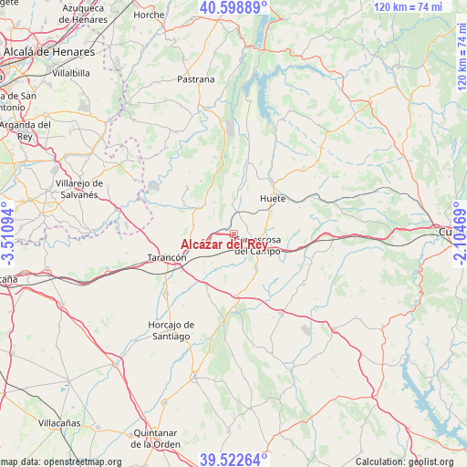
Alcázar del Rey GPS coordinates[2]
40° 3' 46.404" North, 2° 48' 28.152" West
| Map corner | latitude | longitude |
|---|---|---|
| Upper-left | 40.59889°, | -3.51094° |
| Center: | 40.06289°, | -2.80782° |
| Lower-right: | 39.52264°, | -2.10469° |
| Map W x H: | 119.7×119.7 km | = 74.4×74.4mi |
| max Lat: | 43.74134° ⇑69.3% North |
| Alcázar del Rey: | 40.06289° |
| min Lat: | ⇓30.7% South 27.64134° |
| min Long | Alcázar del Re | max Long |
| -18.00367° | -2.80782° | 4.2899° |
| W 57.3%⇐ | ⇒42.7% E |
Elevation
Elevation of Alcázar del Rey is 874 m = 2867 ft, and this is 276 m = 906 ft above average elevation for this country.
| Max E: |
1682 m = 5518 ft | 22.6% |
| Alcázar del Rey | 874 m 2867 ft | |
| Avg. | 598 m = 1962 ft | |
Min E: |
0 m = 0 ft | 77.4% |
See also: Spain elevation on elevation.city.
Geographical zone
Alcázar del Rey is located in North temperate zone (between Tropic of Cancer and the Arctic Circle). Distance of this Northern Tropic circle is 1848.7 km =1148.7 mi to South.| Distance of | km | miles | from Alcázar del Rey |
|---|---|---|---|
| North Pole | 5552.5 | 3450.2 | to North |
| Arctic Circle | 2946.6 | 1830.9 | to North |
| Tropic Cancer | 1848.7 | 1148.7 | to South |
| Equator | 4454.6 | 2768 | to South |


Nearby cities:
15 places around Alcázar del Rey: (largest is in red/bold)
• Barajas de Melo
11.5 km =7.1 mi,  305°
305°
• Huelves
6.9 km =4.3 mi,  251°
251°
• Huete
13.6 km =8.5 mi,  47°
47°
• Illana
16 km =9.9 mi,  327°
327°
• Leganiel
16.6 km =10.3 mi, 313°
• Paredes
3.9 km =2.4 mi,  274°
274°
• Rozalén del Monte
8 km =5 mi,  178°
178°
• Saceda-Trasierra
11 km =6.8 mi,  339°
339°
• Saelices
15.8 km =9.8 mi, 179°
• Tarancón
18 km =11.2 mi, 250°
• Torrejoncillo del Rey
21 km =13 mi,  106°
106°
• Tribaldos
12.6 km =7.8 mi,  217°
217°
• Uclés
10.3 km =6.4 mi,  206°
206°
• Vellisca
7.4 km =4.6 mi,  355°
355°
• Villarrubio
15 km =9.3 mi, 209°
Sources, notices
• [Note1] Compared only with cities in Spain existing in our database
• [Src1] Map data: © OpenStreetMap contributors (CC-BY-SA)
• [Src2] Other city data from geonames.org with taken over terms of usage.
• [Src3] Geographical zone / Annual Mean Temperature by Robert A. Rohde @ Wikipedia
