Trujillo geodata
Trujillo (Extremadura) is a seat of a third-order administrative division; located in Spain in Europe/Madrid (GMT+2) time zone. With population of 9,317 people, there are 885 cities with bigger population in this country. Compared to other cities in Spain, 77.3% of cities are located further ↑North; 84.4% of cities are located further →East and 60.5% of cities have higher elevation than Trujillo. Note1


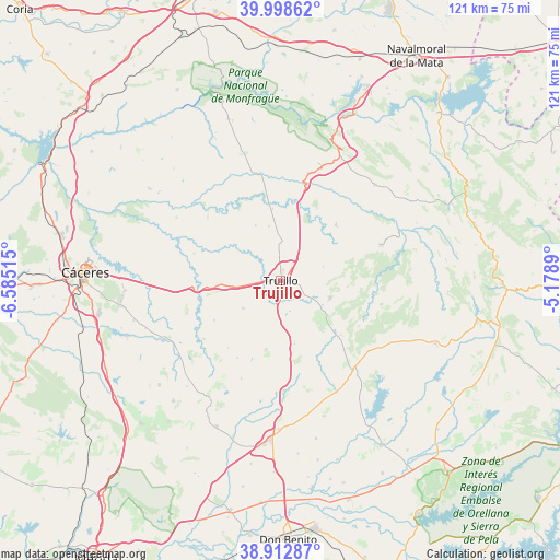
Trujillo GPS coordinates[2]
39° 27' 28.296" North, 5° 52' 55.308" West
| Map corner | latitude | longitude |
|---|---|---|
| Upper-left | 39.99862°, | -6.58515° |
| Center: | 39.45786°, | -5.88203° |
| Lower-right: | 38.91287°, | -5.1789° |
| Map W x H: | 120.7×120.7 km | = 75×75mi |
| max Lat: | 43.74134° ⇑77.3% North |
| Trujillo: | 39.45786° |
| min Lat: | ⇓22.7% South 27.64134° |
| min Long | Trujillo | max Long |
| -18.00367° | -5.88203° | 4.2899° |
| W 15.6%⇐ | ⇒84.4% E |
Elevation
Elevation of Trujillo is 520 m = 1706 ft, and this is 78 m = 256 ft below average elevation for this country.
| Max E: |
1682 m = 5518 ft | 60.5% |
| Avg. | 598 m = 1962 ft | |
| Trujillo | 520 m = 1706 ft | |
Min E: |
0 m = 0 ft | 39.5% |
See also: Spain elevation on elevation.city.
Geographical zone
Trujillo is located in North temperate zone (between Tropic of Cancer and the Arctic Circle). Distance of this Northern Tropic circle is 1781.4 km =1106.9 mi to South.| Distance of | km | miles | from Trujillo |
|---|---|---|---|
| North Pole | 5619.8 | 3492 | to North |
| Arctic Circle | 3013.9 | 1872.8 | to North |
| Tropic Cancer | 1781.4 | 1106.9 | to South |
| Equator | 4387.3 | 2726.1 | to South |


Nearby cities:
15 places around Trujillo: (largest is in red/bold)
• Botija
20.7 km =12.9 mi,  232°
232°
• Conquista de la Sierra
17.4 km =10.8 mi,  133°
133°
• Garcíaz
22.4 km =13.9 mi,  102°
102°
• Herguijuela
14 km =8.7 mi, 131°
• Ibahernando
15.1 km =9.4 mi,  191°
191°
• La Cumbre
10 km =6.2 mi, 233°
• Madroñera
11.4 km =7.1 mi,  108°
108°
• Plasenzuela
16.6 km =10.3 mi,  239°
239°
• Puerto de Santa Cruz
15.9 km =9.9 mi,  172°
172°
• Ruanes
18.3 km =11.4 mi,  218°
218°
• Salvatierra de Santiago
21.5 km =13.4 mi, 216°
• Santa Ana
19.1 km =11.9 mi,  209°
209°
• Santa Cruz de la Sierra
13.9 km =8.6 mi, 166°
• Santa Marta de Magasca
19.5 km =12.1 mi,  287°
287°
• Torrecillas de la Tiesa
17.2 km =10.7 mi,  44°
44°
Sources, notices
• [Note1] Compared only with cities in Spain existing in our database
• [Src1] Map data: © OpenStreetMap contributors (CC-BY-SA)
• [Src2] Other city data from geonames.org with taken over terms of usage.
• [Src3] Geographical zone / Annual Mean Temperature by Robert A. Rohde @ Wikipedia
