Garcíaz geodata
Garcíaz (Extremadura) is a populated place; located in Spain in Europe/Madrid (GMT+2) time zone. With population of 909 people, there are 3059 cities with bigger population in this country. Compared to other cities in Spain, 77.7% of cities are located further ↑North; 80.6% of cities are located further →East and 51% of cities have lower elevation than Garcíaz. Note1


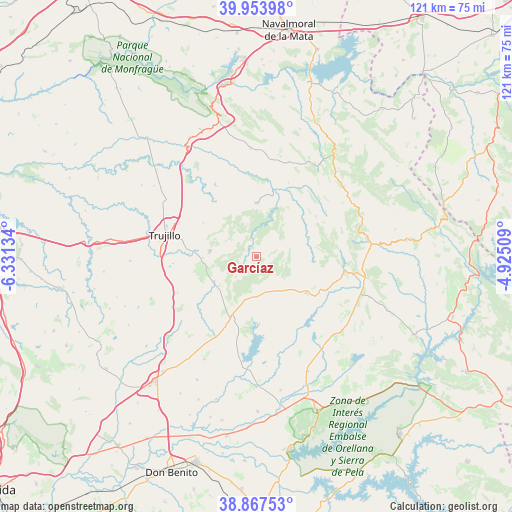
Garcíaz GPS coordinates[2]
39° 24' 46.332" North, 5° 37' 41.556" West
| Map corner | latitude | longitude |
|---|---|---|
| Upper-left | 39.95398°, | -6.33134° |
| Center: | 39.41287°, | -5.62821° |
| Lower-right: | 38.86753°, | -4.92509° |
| Map W x H: | 120.8×120.8 km | = 75.1×75.1mi |
| max Lat: | 43.74134° ⇑77.7% North |
| Garcíaz: | 39.41287° |
| min Lat: | ⇓22.3% South 27.64134° |
| min Long | Garcíaz | max Long |
| -18.00367° | -5.62821° | 4.2899° |
| W 19.4%⇐ | ⇒80.6% E |
Elevation
Elevation of Garcíaz is 669 m = 2195 ft, and this is 71 m = 233 ft above average elevation for this country.
| Max E: |
1682 m = 5518 ft | 49% |
| Garcíaz | 669 m 2195 ft | |
| Avg. | 598 m = 1962 ft | |
Min E: |
0 m = 0 ft | 51% |
See also: Spain elevation on elevation.city.
Geographical zone
Garcíaz is located in North temperate zone (between Tropic of Cancer and the Arctic Circle). Distance of this Northern Tropic circle is 1776.4 km =1103.8 mi to South.| Distance of | km | miles | from Garcíaz |
|---|---|---|---|
| North Pole | 5624.8 | 3495.1 | to North |
| Arctic Circle | 3018.9 | 1875.9 | to North |
| Tropic Cancer | 1776.4 | 1103.8 | to South |
| Equator | 4382.3 | 2723 | to South |


Nearby cities:
15 places around Garcíaz: (largest is in red/bold)
• Alcollarín
21 km =13 mi,  207°
207°
• Aldeacentenera
12.7 km =7.9 mi,  359°
359°
• Berzocana
14.6 km =9.1 mi,  79°
79°
• Cabañas del Castillo
18 km =11.2 mi,  33°
33°
• Cañamero
20.9 km =13 mi,  100°
100°
• Conquista de la Sierra
11.5 km =7.1 mi,  232°
232°
• Herguijuela
12.1 km =7.5 mi,  249°
249°
• Logrosán
14.4 km =8.9 mi,  126°
126°
• Madroñera
11 km =6.8 mi,  277°
277°
• Navezuelas
19.6 km =12.2 mi,  56°
56°
• Puerto de Santa Cruz
22.5 km =14 mi,  241°
241°
• Santa Cruz de la Sierra
20.5 km =12.7 mi, 245°
• Torrecillas de la Tiesa
19.9 km =12.4 mi,  330°
330°
• Trujillo
22.4 km =13.9 mi, 282°
• Zorita
15.5 km =9.6 mi,  203°
203°
Sources, notices
• [Note1] Compared only with cities in Spain existing in our database
• [Src1] Map data: © OpenStreetMap contributors (CC-BY-SA)
• [Src2] Other city data from geonames.org with taken over terms of usage.
• [Src3] Geographical zone / Annual Mean Temperature by Robert A. Rohde @ Wikipedia
