La Cumbre geodata
La Cumbre (Extremadura) is a populated place; located in Spain in Europe/Madrid (GMT+2) time zone. With population of 1,027 people, there are 2902 cities with bigger population in this country. Compared to other cities in Spain, 77.8% of cities are located further ↑North; 85.7% of cities are located further →East and 63.4% of cities have higher elevation than La Cumbre. Note1


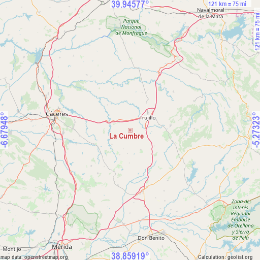
La Cumbre GPS coordinates[2]
39° 24' 16.56" North, 5° 58' 34.86" West
| Map corner | latitude | longitude |
|---|---|---|
| Upper-left | 39.94577°, | -6.67948° |
| Center: | 39.4046°, | -5.97635° |
| Lower-right: | 38.85919°, | -5.27323° |
| Map W x H: | 120.8×120.8 km | = 75.1×75.1mi |
| max Lat: | 43.74134° ⇑77.8% North |
| La Cumbre: | 39.4046° |
| min Lat: | ⇓22.2% South 27.64134° |
| min Long | La Cumbre | max Long |
| -18.00367° | -5.97635° | 4.2899° |
| W 14.3%⇐ | ⇒85.7% E |
Elevation
Elevation of La Cumbre is 482 m = 1581 ft, and this is 116 m = 381 ft below average elevation for this country.
| Max E: |
1682 m = 5518 ft | 63.4% |
| Avg. | 598 m = 1962 ft | |
| La Cumbre | 482 m = 1581 ft | |
Min E: |
0 m = 0 ft | 36.6% |
See also: Spain elevation on elevation.city.
Geographical zone
La Cumbre is located in North temperate zone (between Tropic of Cancer and the Arctic Circle). Distance of this Northern Tropic circle is 1775.5 km =1103.2 mi to South.| Distance of | km | miles | from La Cumbre |
|---|---|---|---|
| North Pole | 5625.7 | 3495.6 | to North |
| Arctic Circle | 3019.8 | 1876.4 | to North |
| Tropic Cancer | 1775.5 | 1103.2 | to South |
| Equator | 4381.4 | 2722.5 | to South |


Nearby cities:
15 places around La Cumbre: (largest is in red/bold)
• Benquerencia
14.1 km =8.8 mi,  221°
221°
• Botija
10.6 km =6.6 mi,  231°
231°
• Herguijuela
18.9 km =11.7 mi,  100°
100°
• Ibahernando
10.1 km =6.3 mi,  150°
150°
• Plasenzuela
6.6 km =4.1 mi,  247°
247°
• Puerto de Santa Cruz
14.1 km =8.8 mi,  134°
134°
• Robledillo de Trujillo
15 km =9.3 mi,  181°
181°
• Ruanes
9.1 km =5.7 mi,  200°
200°
• Salvatierra de Santiago
12.2 km =7.6 mi, 203°
• Santa Ana
10.8 km =6.7 mi,  186°
186°
• Santa Cruz de la Sierra
13.6 km =8.5 mi,  124°
124°
• Santa Marta de Magasca
15.9 km =9.9 mi,  318°
318°
• Torremocha
18.2 km =11.3 mi, 248°
• Trujillo
10 km =6.2 mi,  53°
53°
• Zarza de Montánchez
17 km =10.6 mi, 196°
Sources, notices
• [Note1] Compared only with cities in Spain existing in our database
• [Src1] Map data: © OpenStreetMap contributors (CC-BY-SA)
• [Src2] Other city data from geonames.org with taken over terms of usage.
• [Src3] Geographical zone / Annual Mean Temperature by Robert A. Rohde @ Wikipedia
