Torre-Pacheco geodata
Torre-Pacheco (Murcia) is a populated place; located in Spain in Europe/Madrid (GMT+2) time zone. With population of 31,495 people, there are 284 cities with bigger population in this country. Compared to other cities in Spain, 89.9% of cities are located further ↑North; 77.5% of cities are located further ←West and 92.3% of cities have higher elevation than Torre-Pacheco. Note1


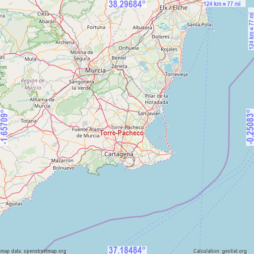
Torre-Pacheco GPS coordinates[2]
37° 44' 34.548" North, 0° 57' 14.256" West
| Map corner | latitude | longitude |
|---|---|---|
| Upper-left | 38.29684°, | -1.65709° |
| Center: | 37.74293°, | -0.95396° |
| Lower-right: | 37.18484°, | -0.25083° |
| Map W x H: | 123.6×123.6 km | = 76.8×76.8mi |
| max Lat: | 43.74134° ⇑89.9% North |
| Torre-Pacheco: | 37.74293° |
| min Lat: | ⇓10.1% South 27.64134° |
| min Long | Torre-Pacheco | max Long |
| -18.00367° | -0.95396° | 4.2899° |
| W 77.5%⇐ | ⇒22.5% E |
Elevation
Elevation of Torre-Pacheco is 43 m = 141 ft, and this is 555 m = 1821 ft below average elevation for this country.
| Max E: |
1682 m = 5518 ft | 92.3% |
| Avg. | 598 m = 1962 ft | |
| Torre-Pacheco | 43 m = 141 ft | |
Min E: |
0 m = 0 ft | 7.7% |
See also: Spain elevation on elevation.city.
Geographical zone
Torre-Pacheco is located in North temperate zone (between Tropic of Cancer and the Arctic Circle). Distance of this Northern Tropic circle is 1590.7 km =988.4 mi to South.| Distance of | km | miles | from Torre-Pacheco |
|---|---|---|---|
| North Pole | 5810.4 | 3610.4 | to North |
| Arctic Circle | 3204.6 | 1991.2 | to North |
| Tropic Cancer | 1590.7 | 988.4 | to South |
| Equator | 4196.6 | 2607.6 | to South |


Nearby cities:
15 places around Torre-Pacheco: (largest is in red/bold)
• Atamaría
20.5 km =12.7 mi,  140°
140°
• Barrio de la Concepción
16.4 km =10.2 mi,  194°
194°
• Cartagena
15.6 km =9.7 mi, 190°
• El Plan
11.7 km =7.3 mi,  208°
208°
• Fuente-Álamo de Murcia
19.1 km =11.9 mi,  263°
263°
• La Unión
15.3 km =9.5 mi,  154°
154°
• Lo Pagán
16.8 km =10.4 mi,  60°
60°
• Los Alcázares
9.1 km =5.7 mi,  89°
89°
• Los Gabatos
12.8 km =8 mi,  198°
198°
• Los Martínez
13.8 km =8.6 mi,  307°
307°
• Pilar de la Horadada
19.7 km =12.2 mi,  46°
46°
• San Javier
12.4 km =7.7 mi, 55°
• San Pedro del Pinatar
17.6 km =10.9 mi, 54°
• Santiago de la Ribera
14.4 km =8.9 mi,  65°
65°
• Valladolises
15.4 km =9.6 mi,  284°
284°
Sources, notices
• [Note1] Compared only with cities in Spain existing in our database
• [Src1] Map data: © OpenStreetMap contributors (CC-BY-SA)
• [Src2] Other city data from geonames.org with taken over terms of usage.
• [Src3] Geographical zone / Annual Mean Temperature by Robert A. Rohde @ Wikipedia
