El Plan geodata
El Plan (Murcia) is a populated place; located in Spain in Europe/Madrid (GMT+2) time zone. With population of 7,497 people, there are 977 cities with bigger population in this country. Compared to other cities in Spain, 90.4% of cities are located further ↑North; 77% of cities are located further ←West and 91.3% of cities have higher elevation than El Plan. Note1


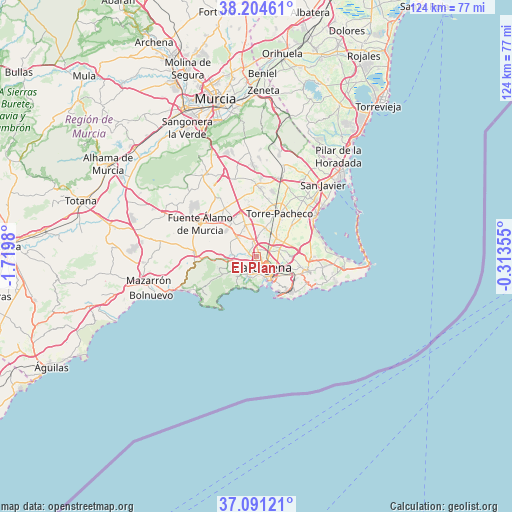
El Plan GPS coordinates[2]
37° 39' 0" North, 1° 1' 0.012" West
| Map corner | latitude | longitude |
|---|---|---|
| Upper-left | 38.20461°, | -1.7198° |
| Center: | 37.65°, | -1.01667° |
| Lower-right: | 37.09121°, | -0.31355° |
| Map W x H: | 123.8×123.8 km | = 76.9×76.9mi |
| max Lat: | 43.74134° ⇑90.4% North |
| El Plan: | 37.65° |
| min Lat: | ⇓9.6% South 27.64134° |
| min Long | El Plan | max Long |
| -18.00367° | -1.01667° | 4.2899° |
| W 77%⇐ | ⇒23% E |
Elevation
Elevation of El Plan is 49 m = 161 ft, and this is 549 m = 1801 ft below average elevation for this country.
| Max E: |
1682 m = 5518 ft | 91.3% |
| Avg. | 598 m = 1962 ft | |
| El Plan | 49 m = 161 ft | |
Min E: |
0 m = 0 ft | 8.7% |
See also: Spain elevation on elevation.city.
Geographical zone
El Plan is located in North temperate zone (between Tropic of Cancer and the Arctic Circle). Distance of this Northern Tropic circle is 1580.4 km =982 mi to South.| Distance of | km | miles | from El Plan |
|---|---|---|---|
| North Pole | 5820.8 | 3616.9 | to North |
| Arctic Circle | 3214.9 | 1997.6 | to North |
| Tropic Cancer | 1580.4 | 982 | to South |
| Equator | 4186.3 | 2601.2 | to South |


Nearby cities:
15 places around El Plan: (largest is in red/bold)
• Atamaría
19.3 km =12 mi,  106°
106°
• Barrio de la Concepción
5.8 km =3.6 mi,  165°
165°
• Cala Reona
26.7 km =16.6 mi,  97°
97°
• Cartagena
5.7 km =3.5 mi,  151°
151°
• Fuente-Álamo de Murcia
15.8 km =9.8 mi,  301°
301°
• La Manga del Mar Menor
26.4 km =16.4 mi,  92°
92°
• La Unión
12.7 km =7.9 mi, 105°
• Los Alcázares
18 km =11.2 mi,  54°
54°
• Los Gabatos
2.4 km =1.5 mi,  141°
141°
• Los Martínez
19.5 km =12.1 mi,  343°
343°
• Mazarrón
26.9 km =16.7 mi,  257°
257°
• San Javier
23.5 km =14.6 mi,  42°
42°
• Santiago de la Ribera
24.7 km =15.3 mi, 48°
• Torre-Pacheco
11.7 km =7.3 mi,  28°
28°
• Valladolises
17 km =10.6 mi,  326°
326°
Sources, notices
• [Note1] Compared only with cities in Spain existing in our database
• [Src1] Map data: © OpenStreetMap contributors (CC-BY-SA)
• [Src2] Other city data from geonames.org with taken over terms of usage.
• [Src3] Geographical zone / Annual Mean Temperature by Robert A. Rohde @ Wikipedia
