Atamaría geodata
Atamaría (Murcia) is a populated place; located in Spain in Europe/Madrid (GMT+1) time zone. With population of 30,000 people, there are 303 cities with bigger population in this country. Compared to other cities in Spain, 90.7% of cities are located further ↑North; 78.7% of cities are located further ←West and 87.8% of cities have higher elevation than Atamaría. Note1


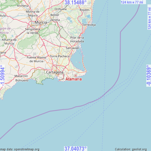
Atamaría GPS coordinates[2]
37° 35' 59.604" North, 0° 48' 24.552" West
| Map corner | latitude | longitude |
|---|---|---|
| Upper-left | 38.15488°, | -1.50994° |
| Center: | 37.59989°, | -0.80682° |
| Lower-right: | 37.04073°, | -0.10369° |
| Map W x H: | 123.9×123.9 km | = 77×77mi |
| max Lat: | 43.74134° ⇑90.7% North |
| Atamaría: | 37.59989° |
| min Lat: | ⇓9.3% South 27.64134° |
| min Long | Atamaría | max Long |
| -18.00367° | -0.80682° | 4.2899° |
| W 78.7%⇐ | ⇒21.3% E |
Elevation
Elevation of Atamaría is 98 m = 322 ft, and this is 500 m = 1640 ft below average elevation for this country.
| Max E: |
1682 m = 5518 ft | 87.8% |
| Avg. | 598 m = 1962 ft | |
| Atamaría | 98 m = 322 ft | |
Min E: |
0 m = 0 ft | 12.2% |
See also: Spain elevation on elevation.city.
Geographical zone
Atamaría is located in North temperate zone (between Tropic of Cancer and the Arctic Circle). Distance of this Northern Tropic circle is 1574.8 km =978.5 mi to South.| Distance of | km | miles | from Atamaría |
|---|---|---|---|
| North Pole | 5826.3 | 3620.3 | to North |
| Arctic Circle | 3220.5 | 2001.1 | to North |
| Tropic Cancer | 1574.8 | 978.5 | to South |
| Equator | 4180.7 | 2597.8 | to South |


Nearby cities:
15 places around Atamaría: (largest is in red/bold)
• Barrio de la Concepción
17 km =10.6 mi,  270°
270°
• Cala Reona
8.2 km =5.1 mi,  76°
76°
• Cartagena
15.8 km =9.8 mi, 272°
• El Plan
19.3 km =12 mi,  286°
286°
• La Manga del Mar Menor
9.2 km =5.7 mi,  59°
59°
• La Unión
6.6 km =4.1 mi, 288°
• Lo Pagán
24.3 km =15.1 mi,  3°
3°
• Los Alcázares
16.5 km =10.3 mi,  346°
346°
• Los Gabatos
17.4 km =10.8 mi,  282°
282°
• Pilar de la Horadada
29.6 km =18.4 mi, 2°
• San Javier
23.1 km =14.4 mi, 353°
• San Pedro del Pinatar
26.3 km =16.3 mi, 3°
• Santiago de la Ribera
21.9 km =13.6 mi, 0°
• Torre de la Horadada
30.3 km =18.8 mi,  8°
8°
• Torre-Pacheco
20.5 km =12.7 mi,  320°
320°
Sources, notices
• [Note1] Compared only with cities in Spain existing in our database
• [Src1] Map data: © OpenStreetMap contributors (CC-BY-SA)
• [Src2] Other city data from geonames.org with taken over terms of usage.
• [Src3] Geographical zone / Annual Mean Temperature by Robert A. Rohde @ Wikipedia
