Cartagena geodata
Cartagena (Murcia) is a seat of a third-order administrative division; located in Spain in Europe/Madrid (GMT+2) time zone. With population of 211,996 people, there are 30 cities with bigger population in this country. Compared to other cities in Spain, 90.7% of cities are located further ↑North; 77.3% of cities are located further ←West and 99.6% of cities have higher elevation than Cartagena. Note1


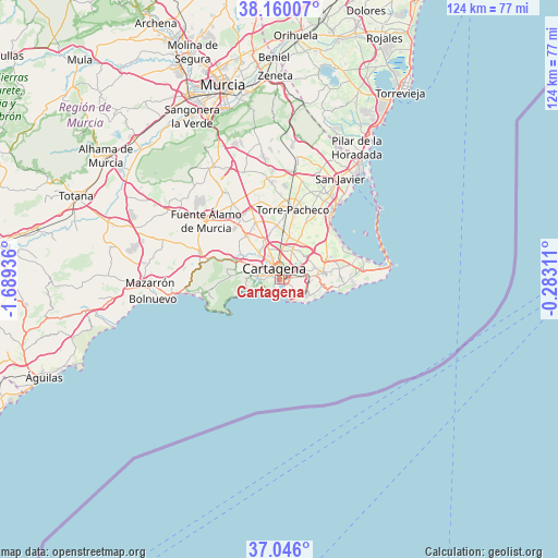
Cartagena GPS coordinates[2]
37° 36' 18.432" North, 0° 59' 10.428" West
| Map corner | latitude | longitude |
|---|---|---|
| Upper-left | 38.16007°, | -1.68936° |
| Center: | 37.60512°, | -0.98623° |
| Lower-right: | 37.046°, | -0.28311° |
| Map W x H: | 123.9×123.9 km | = 77×77mi |
| max Lat: | 43.74134° ⇑90.7% North |
| Cartagena: | 37.60512° |
| min Lat: | ⇓9.3% South 27.64134° |
| min Long | Cartagena | max Long |
| -18.00367° | -0.98623° | 4.2899° |
| W 77.3%⇐ | ⇒22.7% E |
Elevation
Elevation of Cartagena is 5 m = 16 ft, and this is 593 m = 1946 ft below average elevation for this country.
| Max E: |
1682 m = 5518 ft | 99.6% |
| Avg. | 598 m = 1962 ft | |
| Cartagena | 5 m = 16 ft | |
Min E: |
0 m = 0 ft | 0.4% |
See also: Cartagena elevation on elevation.city.
Geographical zone
Cartagena is located in North temperate zone (between Tropic of Cancer and the Arctic Circle). Distance of this Northern Tropic circle is 1575.4 km =978.9 mi to South.| Distance of | km | miles | from Cartagena |
|---|---|---|---|
| North Pole | 5825.8 | 3620 | to North |
| Arctic Circle | 3219.9 | 2000.8 | to North |
| Tropic Cancer | 1575.4 | 978.9 | to South |
| Equator | 4181.3 | 2598.1 | to South |


Nearby cities:
15 places around Cartagena: (largest is in red/bold)
• Atamaría
15.8 km =9.8 mi,  92°
92°
• Barrio de la Concepción
1.3 km =0.8 mi,  244°
244°
• Cala Reona
23.8 km =14.8 mi, 86°
• El Plan
5.7 km =3.5 mi,  331°
331°
• Fuente-Álamo de Murcia
20.9 km =13 mi,  309°
309°
• La Manga del Mar Menor
24.1 km =15 mi,  80°
80°
• La Unión
9.7 km =6 mi, 80°
• Los Alcázares
19.5 km =12.1 mi,  37°
37°
• Los Gabatos
3.4 km =2.1 mi,  338°
338°
• Los Martínez
25.1 km =15.6 mi, 341°
• Mazarrón
29 km =18 mi,  268°
268°
• San Javier
25.9 km =16.1 mi,  30°
30°
• Santiago de la Ribera
26.6 km =16.5 mi, 36°
• Torre-Pacheco
15.6 km =9.7 mi,  10°
10°
• Valladolises
22.6 km =14 mi, 327°
Sources, notices
• [Note1] Compared only with cities in Spain existing in our database
• [Src1] Map data: © OpenStreetMap contributors (CC-BY-SA)
• [Src2] Other city data from geonames.org with taken over terms of usage.
• [Src3] Geographical zone / Annual Mean Temperature by Robert A. Rohde @ Wikipedia
