Tébar geodata
Tébar (Castille-La Mancha) is a seat of a third-order administrative division; located in Spain in Europe/Madrid (GMT+2) time zone. With population of 406 people, there are 4123 cities with bigger population in this country. Compared to other cities in Spain, 76.9% of cities are located further ↑North; 65.2% of cities are located further ←West and 78.2% of cities have lower elevation than Tébar. Note1


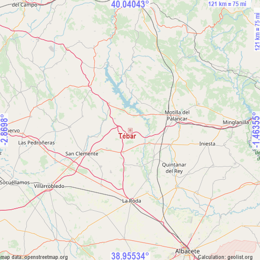
Tébar GPS coordinates[2]
39° 30' 0" North, 2° 10' 0.012" West
| Map corner | latitude | longitude |
|---|---|---|
| Upper-left | 40.04043°, | -2.8698° |
| Center: | 39.5°, | -2.16667° |
| Lower-right: | 38.95534°, | -1.46355° |
| Map W x H: | 120.7×120.7 km | = 75×75mi |
| max Lat: | 43.74134° ⇑76.9% North |
| Tébar: | 39.5° |
| min Lat: | ⇓23.1% South 27.64134° |
| min Long | Tébar | max Long |
| -18.00367° | -2.16667° | 4.2899° |
| W 65.2%⇐ | ⇒34.8% E |
Elevation
Elevation of Tébar is 881 m = 2890 ft, and this is 283 m = 928 ft above average elevation for this country.
| Max E: |
1682 m = 5518 ft | 21.8% |
| Tébar | 881 m 2890 ft | |
| Avg. | 598 m = 1962 ft | |
Min E: |
0 m = 0 ft | 78.2% |
See also: Spain elevation on elevation.city.
Geographical zone
Tébar is located in North temperate zone (between Tropic of Cancer and the Arctic Circle). Distance of this Northern Tropic circle is 1786.1 km =1109.8 mi to South.| Distance of | km | miles | from Tébar |
|---|---|---|---|
| North Pole | 5615.1 | 3489.1 | to North |
| Arctic Circle | 3009.2 | 1869.8 | to North |
| Tropic Cancer | 1786.1 | 1109.8 | to South |
| Equator | 4392 | 2729.1 | to South |


Nearby cities:
15 places around Tébar: (largest is in red/bold)
• Alarcón
9.1 km =5.7 mi,  52°
52°
• Atalaya del Cañavate
7.6 km =4.7 mi,  285°
285°
• Barchín del Hoyo
20.4 km =12.7 mi,  24°
24°
• Buenache de Alarcón
16.7 km =10.4 mi,  0°
0°
• Casas de Benítez
15.1 km =9.4 mi,  169°
169°
• Casas de Guijarro
16.7 km =10.4 mi,  180°
180°
• Casasimarro
18.7 km =11.6 mi,  142°
142°
• El Picazo
9.1 km =5.7 mi,  127°
127°
• Honrubia
16 km =9.9 mi,  322°
322°
• Olmedilla de Alarcón
14.2 km =8.8 mi, 23°
• Pozoamargo
15.2 km =9.4 mi,  189°
189°
• Sisante
10.6 km =6.6 mi,  196°
196°
• Valhermoso de la Fuente
14.8 km =9.2 mi,  60°
60°
• Valverdejo
18.3 km =11.4 mi,  44°
44°
• Vara de Rey
13.7 km =8.5 mi,  233°
233°
Sources, notices
• [Note1] Compared only with cities in Spain existing in our database
• [Src1] Map data: © OpenStreetMap contributors (CC-BY-SA)
• [Src2] Other city data from geonames.org with taken over terms of usage.
• [Src3] Geographical zone / Annual Mean Temperature by Robert A. Rohde @ Wikipedia
