Valhermoso de la Fuente geodata
Valhermoso de la Fuente (Castille-La Mancha) is a seat of a third-order administrative division; located in Spain in Europe/Madrid (GMT+2) time zone. With population of 44 people, there are 6527 cities with bigger population in this country. Compared to other cities in Spain, 76.2% of cities are located further ↑North; 67.3% of cities are located further ←West and 72.3% of cities have lower elevation than Valhermoso de la Fuente. Note1
Administrative division(s):
- Level 1: Castille-La Mancha
- Level 2: Provincia de Cuenca
- Level 3: Valhermoso de la Fuente
Current local time in Valhermoso de la Fuente:
10:46 PM, ThursdayDifference from your time zone: hours


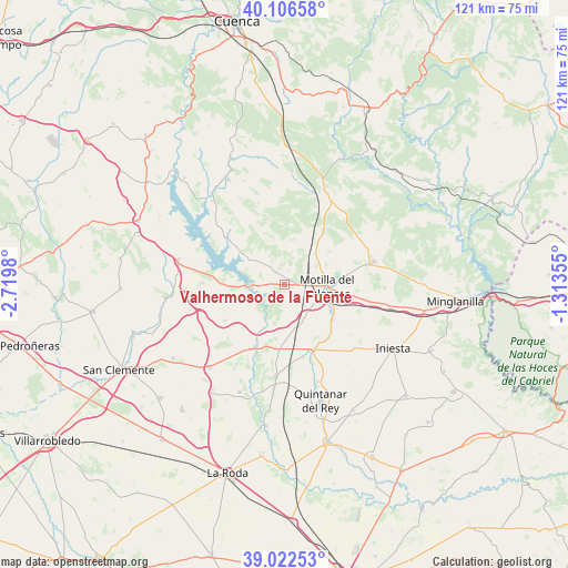
Valhermoso de la Fuente GPS coordinates[2]
39° 34' 0.012" North, 2° 1' 0.012" West
| Map corner | latitude | longitude |
|---|---|---|
| Upper-left | 40.10658°, | -2.7198° |
| Center: | 39.56667°, | -2.01667° |
| Lower-right: | 39.02253°, | -1.31355° |
| Map W x H: | 120.5×120.5 km | = 74.9×74.9mi |
| max Lat: | 43.74134° ⇑76.2% North |
| Valhermoso de la Fuente: | 39.56667° |
| min Lat: | ⇓23.8% South 27.64134° |
| min Long | Valhermoso de l | max Long |
| -18.00367° | -2.01667° | 4.2899° |
| W 67.3%⇐ | ⇒32.7% E |
Elevation
Elevation of Valhermoso de la Fuente is 829 m = 2720 ft, and this is 231 m = 758 ft above average elevation for this country.
| Max E: |
1682 m = 5518 ft | 27.7% |
| Valhermoso de la Fuente | 829 m 2720 ft | |
| Avg. | 598 m = 1962 ft | |
Min E: |
0 m = 0 ft | 72.3% |
See also: Spain elevation on elevation.city.
Geographical zone
Valhermoso de la Fuente is located in North temperate zone (between Tropic of Cancer and the Arctic Circle). Distance of this Northern Tropic circle is 1793.5 km =1114.4 mi to South.| Distance of | km | miles | from Valhermoso de la Fuente |
|---|---|---|---|
| North Pole | 5607.7 | 3484.5 | to North |
| Arctic Circle | 3001.8 | 1865.2 | to North |
| Tropic Cancer | 1793.5 | 1114.4 | to South |
| Equator | 4399.4 | 2733.7 | to South |


Nearby cities:
15 places around Valhermoso de la Fuente: (largest is in red/bold)
• Alarcón
6 km =3.7 mi,  252°
252°
• Almodóvar del Pinar
20.2 km =12.6 mi,  34°
34°
• Barchín del Hoyo
11.9 km =7.4 mi,  338°
338°
• Buenache de Alarcón
15.8 km =9.8 mi,  305°
305°
• Campillo de Altobuey
18.9 km =11.7 mi,  78°
78°
• El Peral
12.5 km =7.8 mi,  126°
126°
• El Picazo
14.2 km =8.8 mi,  203°
203°
• Gabaldón
9 km =5.6 mi,  52°
52°
• Hontecillas
20.6 km =12.8 mi,  316°
316°
• Motilla del Palancar
11.4 km =7.1 mi,  90°
90°
• Olmedilla de Alarcón
9 km =5.6 mi, 307°
• Piqueras del Castillo
17.2 km =10.7 mi,  345°
345°
• Tébar
14.8 km =9.2 mi,  240°
240°
• Valverdejo
5.6 km =3.5 mi,  0°
0°
• Villanueva de la Jara
16.5 km =10.3 mi,  154°
154°
Sources, notices
• [Note1] Compared only with cities in Spain existing in our database
• [Src1] Map data: © OpenStreetMap contributors (CC-BY-SA)
• [Src2] Other city data from geonames.org with taken over terms of usage.
• [Src3] Geographical zone / Annual Mean Temperature by Robert A. Rohde @ Wikipedia
