Tanque geodata
Tanque (Canary Islands) is a populated place; located in Spain in Atlantic/Canary (GMT+1) time zone. With population of 3,068 people, there are 1700 cities with bigger population in this country. Compared to other cities in Spain, 99.2% of cities are located further ↑North; 99.6% of cities are located further →East and 84.9% of cities have higher elevation than Tanque. Note1
Administrative division(s):
- Level 1: Canary Islands
- Level 2: Provincia de Santa Cruz de Tenerife
- Level 3: Buenavista del Norte


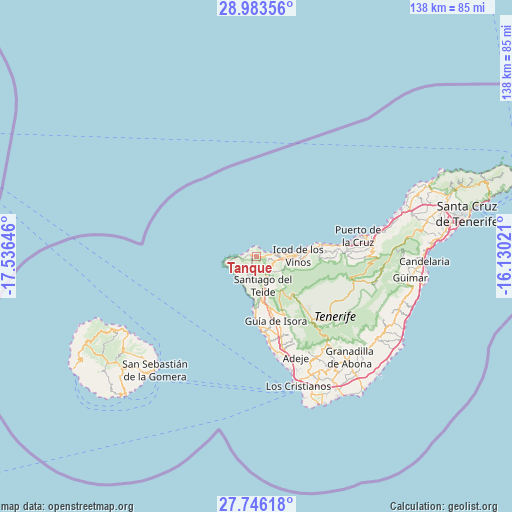
Tanque GPS coordinates[2]
28° 22' 0.012" North, 16° 49' 59.988" West
| Map corner | latitude | longitude |
|---|---|---|
| Upper-left | 28.98356°, | -17.53646° |
| Center: | 28.36667°, | -16.83333° |
| Lower-right: | 27.74618°, | -16.13021° |
| Map W x H: | 137.6×137.6 km | = 85.5×85.5mi |
| max Lat: | 43.74134° ⇑99.2% North |
| Tanque: | 28.36667° |
| min Lat: | ⇓0.8% South 27.64134° |
| min Long | Tanque | max Long |
| -18.00367° | -16.83333° | 4.2899° |
| W 0.4%⇐ | ⇒99.6% E |
Elevation
Elevation of Tanque is 141 m = 463 ft, and this is 457 m = 1499 ft below average elevation for this country.
| Max E: |
1682 m = 5518 ft | 84.9% |
| Avg. | 598 m = 1962 ft | |
| Tanque | 141 m = 463 ft | |
Min E: |
0 m = 0 ft | 15.1% |
See also: Spain elevation on elevation.city.
Geographical zone
Tanque is located in North temperate zone (between Tropic of Cancer and the Arctic Circle). Distance of this Northern Tropic circle is 548.2 km =340.6 mi to South.| Distance of | km | miles | from Tanque |
|---|---|---|---|
| North Pole | 6853 | 4258.3 | to North |
| Arctic Circle | 4247.1 | 2639 | to North |
| Tropic Cancer | 548.2 | 340.6 | to South |
| Equator | 3154.1 | 1959.9 | to South |


Nearby cities:
15 places around Tanque: (largest is in red/bold)
• Adeje
29.1 km =18.1 mi,  158°
158°
• Buenavista del Norte
2.8 km =1.7 mi,  288°
288°
• Garachico
6.9 km =4.3 mi,  83°
83°
• Guía de Isora
18 km =11.2 mi, 163°
• Icod de los Vinos
11.9 km =7.4 mi,  86°
86°
• La Guancha
17.8 km =11.1 mi, 87°
• Los Gigantes
13.7 km =8.5 mi,  183°
183°
• Los Realejos
24.6 km =15.3 mi, 85°
• Los Silos
1.7 km =1.1 mi, 92°
• Puerto de Santiago
14.5 km =9 mi, 183°
• Puerto de la Cruz
28.3 km =17.6 mi, 79°
• Realejo Alto
24.2 km =15 mi, 87°
• San Juan de la Rambla
18.2 km =11.3 mi, 80°
• Santiago del Teide
8.3 km =5.2 mi,  168°
168°
• Vilaflor
30.4 km =18.9 mi,  140°
140°
Sources, notices
• [Note1] Compared only with cities in Spain existing in our database
• [Src1] Map data: © OpenStreetMap contributors (CC-BY-SA)
• [Src2] Other city data from geonames.org with taken over terms of usage.
• [Src3] Geographical zone / Annual Mean Temperature by Robert A. Rohde @ Wikipedia
