Socuéllamos geodata
Socuéllamos (Castille-La Mancha) is a seat of a third-order administrative division; located in Spain in Europe/Madrid (GMT+2) time zone. With population of 13,163 people, there are 699 cities with bigger population in this country. Compared to other cities in Spain, 78.6% of cities are located further ↑North; 57.6% of cities are located further ←West and 52.3% of cities have lower elevation than Socuéllamos. Note1
Administrative division(s):
- Level 1: Castille-La Mancha
- Level 2: Provincia de Ciudad Real
- Level 3: Socuéllamos


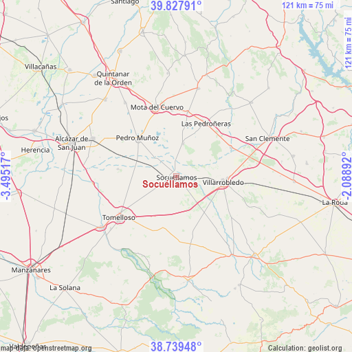
Socuéllamos GPS coordinates[2]
39° 17' 8.916" North, 2° 47' 31.38" West
| Map corner | latitude | longitude |
|---|---|---|
| Upper-left | 39.82791°, | -3.49517° |
| Center: | 39.28581°, | -2.79205° |
| Lower-right: | 38.73948°, | -2.08892° |
| Map W x H: | 121×121 km | = 75.2×75.2mi |
| max Lat: | 43.74134° ⇑78.6% North |
| Socuéllamos: | 39.28581° |
| min Lat: | ⇓21.4% South 27.64134° |
| min Long | Socuéllamos | max Long |
| -18.00367° | -2.79205° | 4.2899° |
| W 57.6%⇐ | ⇒42.4% E |
Elevation
Elevation of Socuéllamos is 682 m = 2238 ft, and this is 84 m = 276 ft above average elevation for this country.
| Max E: |
1682 m = 5518 ft | 47.7% |
| Socuéllamos | 682 m 2238 ft | |
| Avg. | 598 m = 1962 ft | |
Min E: |
0 m = 0 ft | 52.3% |
See also: Spain elevation on elevation.city.
Geographical zone
Socuéllamos is located in North temperate zone (between Tropic of Cancer and the Arctic Circle). Distance of this Northern Tropic circle is 1762.3 km =1095 mi to South.| Distance of | km | miles | from Socuéllamos |
|---|---|---|---|
| North Pole | 5638.9 | 3503.8 | to North |
| Arctic Circle | 3033 | 1884.6 | to North |
| Tropic Cancer | 1762.3 | 1095 | to South |
| Equator | 4368.2 | 2714.3 | to South |


Nearby cities:
15 places around Socuéllamos: (largest is in red/bold)
• Argamasilla de Alba
31.2 km =19.4 mi,  236°
236°
• Belmonte
31.1 km =19.3 mi,  13°
13°
• Campo de Criptana
31.5 km =19.6 mi,  294°
294°
• El Pedernoso
22.6 km =14 mi, 10°
• El Provencio
21.3 km =13.2 mi,  61°
61°
• El Toboso
30.8 km =19.1 mi,  325°
325°
• Las Mesas
11.7 km =7.3 mi, 11°
• Las Pedroñeras
20.9 km =13 mi,  29°
29°
• Monreal del Llano
31.6 km =19.6 mi,  4°
4°
• Mota del Cuervo
24.9 km =15.5 mi,  344°
344°
• Pedro Muñoz
18.6 km =11.6 mi,  314°
314°
• San Clemente
33.9 km =21.1 mi,  67°
67°
• Santa María de los Llanos
22.9 km =14.2 mi, 343°
• Tomelloso
24.4 km =15.2 mi,  234°
234°
• Villarrobledo
16.5 km =10.3 mi,  96°
96°
Sources, notices
• [Note1] Compared only with cities in Spain existing in our database
• [Src1] Map data: © OpenStreetMap contributors (CC-BY-SA)
• [Src2] Other city data from geonames.org with taken over terms of usage.
• [Src3] Geographical zone / Annual Mean Temperature by Robert A. Rohde @ Wikipedia
