Belmonte geodata
Belmonte (Castille-La Mancha) is a seat of a third-order administrative division; located in Spain in Europe/Madrid (GMT+2) time zone. With population of 2,360 people, there are 1962 cities with bigger population in this country. Compared to other cities in Spain, 76.3% of cities are located further ↑North; 58.6% of cities are located further ←West and 60.7% of cities have lower elevation than Belmonte. Note1
Administrative division(s):
- Level 1: Castille-La Mancha
- Level 2: Provincia de Cuenca
- Level 3: Belmonte


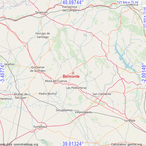
Belmonte GPS coordinates[2]
39° 33' 26.856" North, 2° 42' 16.596" West
| Map corner | latitude | longitude |
|---|---|---|
| Upper-left | 40.09744°, | -3.40774° |
| Center: | 39.55746°, | -2.70461° |
| Lower-right: | 39.01324°, | -2.00149° |
| Map W x H: | 120.6×120.6 km | = 74.9×74.9mi |
| max Lat: | 43.74134° ⇑76.3% North |
| Belmonte: | 39.55746° |
| min Lat: | ⇓23.7% South 27.64134° |
| min Long | Belmonte | max Long |
| -18.00367° | -2.70461° | 4.2899° |
| W 58.6%⇐ | ⇒41.4% E |
Elevation
Elevation of Belmonte is 749 m = 2457 ft, and this is 151 m = 495 ft above average elevation for this country.
| Max E: |
1682 m = 5518 ft | 39.3% |
| Belmonte | 749 m 2457 ft | |
| Avg. | 598 m = 1962 ft | |
Min E: |
0 m = 0 ft | 60.7% |
See also: Spain elevation on elevation.city.
Geographical zone
Belmonte is located in North temperate zone (between Tropic of Cancer and the Arctic Circle). Distance of this Northern Tropic circle is 1792.5 km =1113.8 mi to South.| Distance of | km | miles | from Belmonte |
|---|---|---|---|
| North Pole | 5608.7 | 3485.1 | to North |
| Arctic Circle | 3002.8 | 1865.9 | to North |
| Tropic Cancer | 1792.5 | 1113.8 | to South |
| Equator | 4398.4 | 2733 | to South |


Nearby cities:
15 places around Belmonte: (largest is in red/bold)
• Carrascosa de Haro
14.6 km =9.1 mi,  72°
72°
• El Pedernoso
8.7 km =5.4 mi,  204°
204°
• Fuentelespino de Haro
15 km =9.3 mi,  11°
11°
• La Alberca de Záncara
18.8 km =11.7 mi,  104°
104°
• Las Mesas
19.5 km =12.1 mi, 195°
• Las Pedroñeras
12.2 km =7.6 mi,  167°
167°
• Los Hinojosos
11.6 km =7.2 mi,  296°
296°
• Monreal del Llano
5 km =3.1 mi,  284°
284°
• Mota del Cuervo
15.5 km =9.6 mi,  246°
246°
• Osa de la Vega
12.3 km =7.6 mi,  337°
337°
• Rada de Haro
7.3 km =4.5 mi,  78°
78°
• Santa María de los Llanos
16.2 km =10.1 mi,  239°
239°
• Tresjuncos
16.5 km =10.3 mi, 344°
• Villaescusa de Haro
5.3 km =3.3 mi,  30°
30°
• Villar de la Encina
18 km =11.2 mi,  60°
60°
Sources, notices
• [Note1] Compared only with cities in Spain existing in our database
• [Src1] Map data: © OpenStreetMap contributors (CC-BY-SA)
• [Src2] Other city data from geonames.org with taken over terms of usage.
• [Src3] Geographical zone / Annual Mean Temperature by Robert A. Rohde @ Wikipedia
