Segorbe geodata
Segorbe (Valencia) is a seat of a third-order administrative division; located in Spain in Europe/Madrid (GMT+2) time zone. With population of 8,371 people, there are 917 cities with bigger population in this country. Compared to other cities in Spain, 72.4% of cities are located further ↑North; 81.9% of cities are located further ←West and 72.4% of cities have higher elevation than Segorbe. Note1


Segorbe GPS coordinates[2]
39° 51' 0" North, 0° 28' 59.988" West
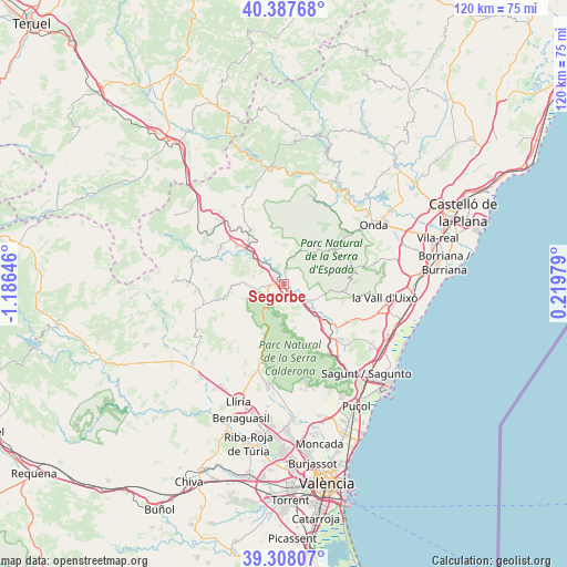
| Map corner | latitude | longitude |
|---|---|---|
| Upper-left | 40.38768°, | -1.18646° |
| Center: | 39.85°, | -0.48333° |
| Lower-right: | 39.30807°, | 0.21979° |
| Map W x H: | 120×120 km | = 74.6×74.6mi |
| max Lat: | 43.74134° ⇑72.4% North |
| Segorbe: | 39.85° |
| min Lat: | ⇓27.6% South 27.64134° |
| min Long | Segorbe | max Long |
| -18.00367° | -0.48333° | 4.2899° |
| W 81.9%⇐ | ⇒18.1% E |
Elevation
Elevation of Segorbe is 340 m = 1115 ft, and this is 258 m = 846 ft below average elevation for this country.
| Max E: |
1682 m = 5518 ft | 72.4% |
| Avg. | 598 m = 1962 ft | |
| Segorbe | 340 m = 1115 ft | |
Min E: |
0 m = 0 ft | 27.6% |
See also: Spain elevation on elevation.city.
Geographical zone
Segorbe is located in North temperate zone (between Tropic of Cancer and the Arctic Circle). Distance of this Northern Tropic circle is 1825 km =1134 mi to South.| Distance of | km | miles | from Segorbe |
|---|---|---|---|
| North Pole | 5576.2 | 3464.9 | to North |
| Arctic Circle | 2970.3 | 1845.7 | to North |
| Tropic Cancer | 1825 | 1134 | to South |
| Equator | 4430.9 | 2753.2 | to South |


Nearby cities:
15 places around Segorbe: (largest is in red/bold)
• Algimia de Almonacid
8.6 km =5.3 mi,  29°
29°
• Almedíjar
7.3 km =4.5 mi,  75°
75°
• Altura
2.8 km =1.7 mi,  270°
270°
• Azuébar
10.1 km =6.3 mi,  100°
100°
• Castellnovo
3.4 km =2.1 mi,  56°
56°
• Gaibiel
9.3 km =5.8 mi,  0°
0°
• Geldo
2.3 km =1.4 mi,  142°
142°
• Jérica
10.3 km =6.4 mi,  316°
316°
• Marines
12.7 km =7.9 mi,  198°
198°
• Matet
9.4 km =5.8 mi,  8°
8°
• Navajas
4 km =2.5 mi,  338°
338°
• Soneja
6.8 km =4.2 mi,  123°
123°
• Sot de Ferrer
9 km =5.6 mi,  127°
127°
• Vall de Almonacid
6.2 km =3.9 mi, 27°
• Viver
12.4 km =7.7 mi,  306°
306°
Sources, notices
• [Note1] Compared only with cities in Spain existing in our database
• [Src1] Map data: © OpenStreetMap contributors (CC-BY-SA)
• [Src2] Other city data from geonames.org with taken over terms of usage.
• [Src3] Geographical zone / Annual Mean Temperature by Robert A. Rohde @ Wikipedia
