Almedíjar geodata
Almedíjar (Valencia) is a seat of a third-order administrative division; located in Spain in Europe/Madrid (GMT+2) time zone. With population of 267 people, there are 4649 cities with bigger population in this country. Compared to other cities in Spain, 72.2% of cities are located further ↑North; 83.1% of cities are located further ←West and 60.5% of cities have lower elevation than Almedíjar. Note1


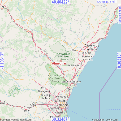
Almedíjar GPS coordinates[2]
39° 52' 0.012" North, 0° 24' 0" West
| Map corner | latitude | longitude |
|---|---|---|
| Upper-left | 40.40422°, | -1.10313° |
| Center: | 39.86667°, | -0.4° |
| Lower-right: | 39.32487°, | 0.30313° |
| Map W x H: | 120×120 km | = 74.6×74.6mi |
| max Lat: | 43.74134° ⇑72.2% North |
| Almedíjar: | 39.86667° |
| min Lat: | ⇓27.8% South 27.64134° |
| min Long | Almedíjar | max Long |
| -18.00367° | -0.4° | 4.2899° |
| W 83.1%⇐ | ⇒16.9% E |
Elevation
Elevation of Almedíjar is 748 m = 2454 ft, and this is 150 m = 492 ft above average elevation for this country.
| Max E: |
1682 m = 5518 ft | 39.5% |
| Almedíjar | 748 m 2454 ft | |
| Avg. | 598 m = 1962 ft | |
Min E: |
0 m = 0 ft | 60.5% |
See also: Spain elevation on elevation.city.
Geographical zone
Almedíjar is located in North temperate zone (between Tropic of Cancer and the Arctic Circle). Distance of this Northern Tropic circle is 1826.8 km =1135.1 mi to South.| Distance of | km | miles | from Almedíjar |
|---|---|---|---|
| North Pole | 5574.3 | 3463.7 | to North |
| Arctic Circle | 2968.4 | 1844.5 | to North |
| Tropic Cancer | 1826.8 | 1135.1 | to South |
| Equator | 4432.8 | 2754.4 | to South |


Nearby cities:
15 places around Almedíjar: (largest is in red/bold)
• Alcudia de Veo
7 km =4.3 mi,  37°
37°
• Algimia de Almonacid
6.2 km =3.9 mi,  332°
332°
• Altura
10.1 km =6.3 mi,  259°
259°
• Azuébar
4.7 km =2.9 mi,  142°
142°
• Castellnovo
4.3 km =2.7 mi,  270°
270°
• Chóvar
7.3 km =4.5 mi,  104°
104°
• Eslida
8.7 km =5.4 mi,  77°
77°
• Gaibiel
10.3 km =6.4 mi,  316°
316°
• Geldo
6.8 km =4.2 mi,  236°
236°
• Matet
9.3 km =5.8 mi, 322°
• Navajas
8.7 km =5.4 mi,  282°
282°
• Segorbe
7.3 km =4.5 mi, 255°
• Soneja
5.7 km =3.5 mi,  194°
194°
• Sot de Ferrer
7.4 km =4.6 mi,  180°
180°
• Vall de Almonacid
5.7 km =3.5 mi,  310°
310°
Sources, notices
• [Note1] Compared only with cities in Spain existing in our database
• [Src1] Map data: © OpenStreetMap contributors (CC-BY-SA)
• [Src2] Other city data from geonames.org with taken over terms of usage.
• [Src3] Geographical zone / Annual Mean Temperature by Robert A. Rohde @ Wikipedia
