Azuébar geodata
Azuébar (Valencia) is a seat of a third-order administrative division; located in Spain in Europe/Madrid (GMT+2) time zone. With population of 357 people, there are 4289 cities with bigger population in this country. Compared to other cities in Spain, 72.5% of cities are located further ↑North; 83.5% of cities are located further ←West and 75.2% of cities have higher elevation than Azuébar. Note1


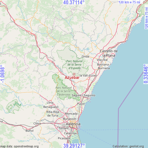
Azuébar GPS coordinates[2]
39° 49' 59.988" North, 0° 22' 0.012" West
| Map corner | latitude | longitude |
|---|---|---|
| Upper-left | 40.37114°, | -1.0698° |
| Center: | 39.83333°, | -0.36667° |
| Lower-right: | 39.29127°, | 0.33646° |
| Map W x H: | 120.1×120.1 km | = 74.6×74.6mi |
| max Lat: | 43.74134° ⇑72.5% North |
| Azuébar: | 39.83333° |
| min Lat: | ⇓27.5% South 27.64134° |
| min Long | Azuébar | max Long |
| -18.00367° | -0.36667° | 4.2899° |
| W 83.5%⇐ | ⇒16.5% E |
Elevation
Elevation of Azuébar is 295 m = 968 ft, and this is 303 m = 994 ft below average elevation for this country.
| Max E: |
1682 m = 5518 ft | 75.2% |
| Avg. | 598 m = 1962 ft | |
| Azuébar | 295 m = 968 ft | |
Min E: |
0 m = 0 ft | 24.8% |
See also: Spain elevation on elevation.city.
Geographical zone
Azuébar is located in North temperate zone (between Tropic of Cancer and the Arctic Circle). Distance of this Northern Tropic circle is 1823.1 km =1132.8 mi to South.| Distance of | km | miles | from Azuébar |
|---|---|---|---|
| North Pole | 5578 | 3466 | to North |
| Arctic Circle | 2972.1 | 1846.8 | to North |
| Tropic Cancer | 1823.1 | 1132.8 | to South |
| Equator | 4429.1 | 2752.1 | to South |


Nearby cities:
15 places around Azuébar: (largest is in red/bold)
• Alcudia de Veo
9.4 km =5.8 mi,  8°
8°
• Alfara de Algimia
7.5 km =4.7 mi,  169°
169°
• Alfondeguilla
8.5 km =5.3 mi,  90°
90°
• Algimia de Alfara
9.3 km =5.8 mi,  180°
180°
• Algimia de Almonacid
10.9 km =6.8 mi,  328°
328°
• Almedíjar
4.7 km =2.9 mi,  322°
322°
• Artana
11.3 km =7 mi,  55°
55°
• Castellnovo
8 km =5 mi,  297°
297°
• Chóvar
4.7 km =2.9 mi,  66°
66°
• Eslida
8 km =5 mi,  45°
45°
• Geldo
8.5 km =5.3 mi,  270°
270°
• Segorbe
10.1 km =6.3 mi,  280°
280°
• Soneja
4.7 km =2.9 mi,  246°
246°
• Sot de Ferrer
4.7 km =2.9 mi,  217°
217°
• Vall de Almonacid
10.3 km =6.4 mi, 316°
Sources, notices
• [Note1] Compared only with cities in Spain existing in our database
• [Src1] Map data: © OpenStreetMap contributors (CC-BY-SA)
• [Src2] Other city data from geonames.org with taken over terms of usage.
• [Src3] Geographical zone / Annual Mean Temperature by Robert A. Rohde @ Wikipedia
