Sot de Ferrer geodata
Sot de Ferrer (Valencia) is a seat of a third-order administrative division; located in Spain in Europe/Madrid (GMT+2) time zone. With population of 504 people, there are 3872 cities with bigger population in this country. Compared to other cities in Spain, 72.9% of cities are located further ↑North; 83.1% of cities are located further ←West and 79.1% of cities have higher elevation than Sot de Ferrer. Note1


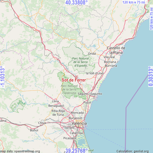
Sot de Ferrer GPS coordinates[2]
39° 48' 0" North, 0° 24' 0" West
| Map corner | latitude | longitude |
|---|---|---|
| Upper-left | 40.33808°, | -1.10313° |
| Center: | 39.8°, | -0.4° |
| Lower-right: | 39.25768°, | 0.30313° |
| Map W x H: | 120.1×120.1 km | = 74.6×74.6mi |
| max Lat: | 43.74134° ⇑72.9% North |
| Sot de Ferrer: | 39.8° |
| min Lat: | ⇓27.1% South 27.64134° |
| min Long | Sot de Ferrer | max Long |
| -18.00367° | -0.4° | 4.2899° |
| W 83.1%⇐ | ⇒16.9% E |
Elevation
Elevation of Sot de Ferrer is 236 m = 774 ft, and this is 362 m = 1188 ft below average elevation for this country.
| Max E: |
1682 m = 5518 ft | 79.1% |
| Avg. | 598 m = 1962 ft | |
| Sot de Ferrer | 236 m = 774 ft | |
Min E: |
0 m = 0 ft | 20.9% |
See also: Spain elevation on elevation.city.
Geographical zone
Sot de Ferrer is located in North temperate zone (between Tropic of Cancer and the Arctic Circle). Distance of this Northern Tropic circle is 1819.4 km =1130.5 mi to South.| Distance of | km | miles | from Sot de Ferrer |
|---|---|---|---|
| North Pole | 5581.7 | 3468.3 | to North |
| Arctic Circle | 2975.8 | 1849.1 | to North |
| Tropic Cancer | 1819.4 | 1130.5 | to South |
| Equator | 4425.3 | 2749.8 | to South |


Nearby cities:
15 places around Sot de Ferrer: (largest is in red/bold)
• Albalat dels Tarongers
12.5 km =7.8 mi,  152°
152°
• Alfara de Algimia
5.7 km =3.5 mi,  130°
130°
• Alfondeguilla
12 km =7.5 mi,  71°
71°
• Algimia de Alfara
6.2 km =3.9 mi, 152°
• Almedíjar
7.4 km =4.6 mi,  0°
0°
• Altura
11.4 km =7.1 mi,  299°
299°
• Azuébar
4.7 km =2.9 mi,  37°
37°
• Castellnovo
8.6 km =5.3 mi,  330°
330°
• Chóvar
9 km =5.6 mi,  52°
52°
• Eslida
12.6 km =7.8 mi, 42°
• Estivella
10.2 km =6.3 mi,  155°
155°
• Geldo
6.8 km =4.2 mi, 303°
• Segorbe
9 km =5.6 mi,  307°
307°
• Soneja
2.3 km =1.4 mi,  322°
322°
• Vall de Almonacid
11.9 km =7.4 mi,  339°
339°
Sources, notices
• [Note1] Compared only with cities in Spain existing in our database
• [Src1] Map data: © OpenStreetMap contributors (CC-BY-SA)
• [Src2] Other city data from geonames.org with taken over terms of usage.
• [Src3] Geographical zone / Annual Mean Temperature by Robert A. Rohde @ Wikipedia
