San Juan de Énova geodata
San Juan de Énova (Valencia) is a seat of a third-order administrative division; located in Spain in Europe/Madrid (GMT+2) time zone. With population of 386 people, there are 4179 cities with bigger population in this country. Compared to other cities in Spain, 80.4% of cities are located further ↑North; 81.8% of cities are located further ←West and 92.7% of cities have higher elevation than San Juan de Énova. Note1


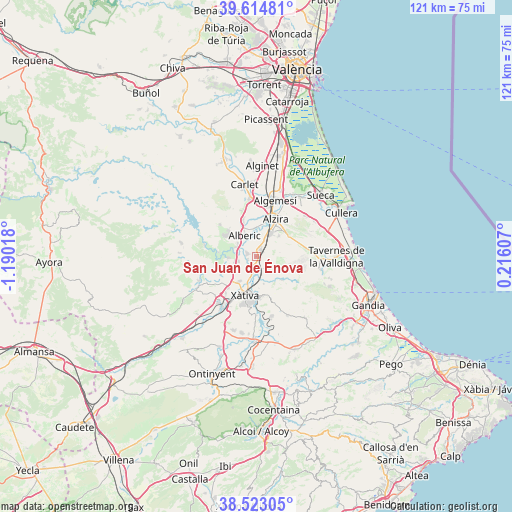
San Juan de Énova GPS coordinates[2]
39° 4' 15.744" North, 0° 29' 13.38" West
| Map corner | latitude | longitude |
|---|---|---|
| Upper-left | 39.61481°, | -1.19018° |
| Center: | 39.07104°, | -0.48705° |
| Lower-right: | 38.52305°, | 0.21607° |
| Map W x H: | 121.4×121.4 km | = 75.4×75.4mi |
| max Lat: | 43.74134° ⇑80.4% North |
| San Juan de Énova: | 39.07104° |
| min Lat: | ⇓19.6% South 27.64134° |
| min Long | San Juan de Én | max Long |
| -18.00367° | -0.48705° | 4.2899° |
| W 81.8%⇐ | ⇒18.2% E |
Elevation
Elevation of San Juan de Énova is 40 m = 131 ft, and this is 558 m = 1831 ft below average elevation for this country.
| Max E: |
1682 m = 5518 ft | 92.7% |
| Avg. | 598 m = 1962 ft | |
| San Juan de Énova | 40 m = 131 ft | |
Min E: |
0 m = 0 ft | 7.3% |
See also: Spain elevation on elevation.city.
Geographical zone
San Juan de Énova is located in North temperate zone (between Tropic of Cancer and the Arctic Circle). Distance of this Northern Tropic circle is 1738.4 km =1080.2 mi to South.| Distance of | km | miles | from San Juan de Énova |
|---|---|---|---|
| North Pole | 5662.8 | 3518.7 | to North |
| Arctic Circle | 3056.9 | 1899.5 | to North |
| Tropic Cancer | 1738.4 | 1080.2 | to South |
| Equator | 4344.3 | 2699.4 | to South |


Nearby cities:
15 places around San Juan de Énova: (largest is in red/bold)
• Alberic
5.7 km =3.5 mi,  333°
333°
• Alcàntera de Xúquer
5.5 km =3.4 mi,  264°
264°
• Beneixida
5.5 km =3.4 mi, 264°
• Benimuslem
6.8 km =4.2 mi,  355°
355°
• Carcaixent
6.6 km =4.1 mi,  30°
30°
• Càrcer
6.9 km =4.3 mi,  265°
265°
• Gavarda
5.6 km =3.5 mi,  284°
284°
• L'Ènova
2.4 km =1.5 mi,  172°
172°
• La Pobla Llarga
2.2 km =1.4 mi,  52°
52°
• Llosa de Ranes
7 km =4.3 mi,  218°
218°
• Lugar Nuevo de Fenollet
6.6 km =4.1 mi,  164°
164°
• Manuel
2.3 km =1.4 mi,  185°
185°
• Rafelguaraf
3.5 km =2.2 mi,  128°
128°
• Senyera
1.2 km =0.7 mi,  246°
246°
• Villanueva de Castellón
2.2 km =1.4 mi,  288°
288°
Sources, notices
• [Note1] Compared only with cities in Spain existing in our database
• [Src1] Map data: © OpenStreetMap contributors (CC-BY-SA)
• [Src2] Other city data from geonames.org with taken over terms of usage.
• [Src3] Geographical zone / Annual Mean Temperature by Robert A. Rohde @ Wikipedia
