Senyera geodata
Senyera (Valencia) is a seat of a third-order administrative division; located in Spain in Europe/Madrid (GMT+2) time zone. With population of 1,038 people, there are 2893 cities with bigger population in this country. Compared to other cities in Spain, 80.5% of cities are located further ↑North; 81.7% of cities are located further ←West and 92.3% of cities have higher elevation than Senyera. Note1


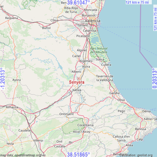
Senyera GPS coordinates[2]
39° 4' 0.012" North, 0° 30' 0" West
| Map corner | latitude | longitude |
|---|---|---|
| Upper-left | 39.61047°, | -1.20313° |
| Center: | 39.06667°, | -0.5° |
| Lower-right: | 38.51865°, | 0.20313° |
| Map W x H: | 121.4×121.4 km | = 75.4×75.4mi |
| max Lat: | 43.74134° ⇑80.5% North |
| Senyera: | 39.06667° |
| min Lat: | ⇓19.5% South 27.64134° |
| min Long | Senyera | max Long |
| -18.00367° | -0.5° | 4.2899° |
| W 81.7%⇐ | ⇒18.3% E |
Elevation
Elevation of Senyera is 43 m = 141 ft, and this is 555 m = 1821 ft below average elevation for this country.
| Max E: |
1682 m = 5518 ft | 92.3% |
| Avg. | 598 m = 1962 ft | |
| Senyera | 43 m = 141 ft | |
Min E: |
0 m = 0 ft | 7.7% |
See also: Spain elevation on elevation.city.
Geographical zone
Senyera is located in North temperate zone (between Tropic of Cancer and the Arctic Circle). Distance of this Northern Tropic circle is 1737.9 km =1079.9 mi to South.| Distance of | km | miles | from Senyera |
|---|---|---|---|
| North Pole | 5663.3 | 3519 | to North |
| Arctic Circle | 3057.4 | 1899.8 | to North |
| Tropic Cancer | 1737.9 | 1079.9 | to South |
| Equator | 4343.8 | 2699.1 | to South |


Nearby cities:
15 places around Senyera: (largest is in red/bold)
• Alberic
5.7 km =3.5 mi,  345°
345°
• Alcàntera de Xúquer
4.3 km =2.7 mi,  270°
270°
• Beneixida
4.3 km =2.7 mi, 270°
• Benimuslem
7.2 km =4.5 mi,  4°
4°
• Cotes
6.4 km =4 mi, 273°
• Càrcer
5.8 km =3.6 mi, 270°
• Gavarda
4.7 km =2.9 mi,  293°
293°
• L'Ènova
2.3 km =1.4 mi,  142°
142°
• La Pobla Llarga
3.4 km =2.1 mi,  57°
57°
• Llosa de Ranes
6 km =3.7 mi,  213°
213°
• Lugar Nuevo de Fenollet
6.6 km =4.1 mi,  153°
153°
• Manuel
2 km =1.2 mi, 153°
• Rafelguaraf
4.2 km =2.6 mi,  114°
114°
• San Juan de Énova
1.2 km =0.7 mi,  66°
66°
• Villanueva de Castellón
1.6 km =1 mi,  319°
319°
Sources, notices
• [Note1] Compared only with cities in Spain existing in our database
• [Src1] Map data: © OpenStreetMap contributors (CC-BY-SA)
• [Src2] Other city data from geonames.org with taken over terms of usage.
• [Src3] Geographical zone / Annual Mean Temperature by Robert A. Rohde @ Wikipedia
