Alberic geodata
Alberic (Valencia) is a seat of a third-order administrative division; located in Spain in Europe/Madrid (GMT+2) time zone. With population of 11,175 people, there are 788 cities with bigger population in this country. Compared to other cities in Spain, 80.1% of cities are located further ↑North; 81.5% of cities are located further ←West and 94.3% of cities have higher elevation than Alberic. Note1


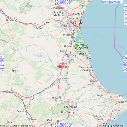
Alberic GPS coordinates[2]
39° 7' 0.012" North, 0° 31' 0.012" West
| Map corner | latitude | longitude |
|---|---|---|
| Upper-left | 39.66008°, | -1.2198° |
| Center: | 39.11667°, | -0.51667° |
| Lower-right: | 38.56903°, | 0.18646° |
| Map W x H: | 121.3×121.3 km | = 75.4×75.4mi |
| max Lat: | 43.74134° ⇑80.1% North |
| Alberic: | 39.11667° |
| min Lat: | ⇓19.9% South 27.64134° |
| min Long | Alberic | max Long |
| -18.00367° | -0.51667° | 4.2899° |
| W 81.5%⇐ | ⇒18.5% E |
Elevation
Elevation of Alberic is 29 m = 95 ft, and this is 569 m = 1867 ft below average elevation for this country.
| Max E: |
1682 m = 5518 ft | 94.3% |
| Avg. | 598 m = 1962 ft | |
| Alberic | 29 m = 95 ft | |
Min E: |
0 m = 0 ft | 5.7% |
See also: Spain elevation on elevation.city.
Geographical zone
Alberic is located in North temperate zone (between Tropic of Cancer and the Arctic Circle). Distance of this Northern Tropic circle is 1743.4 km =1083.3 mi to South.| Distance of | km | miles | from Alberic |
|---|---|---|---|
| North Pole | 5657.7 | 3515.5 | to North |
| Arctic Circle | 3051.8 | 1896.3 | to North |
| Tropic Cancer | 1743.4 | 1083.3 | to South |
| Equator | 4349.4 | 2702.6 | to South |


Nearby cities:
15 places around Alberic: (largest is in red/bold)
• Alcàntera de Xúquer
6.3 km =3.9 mi,  207°
207°
• Antella
7.7 km =4.8 mi,  237°
237°
• Beneixida
6.3 km =3.9 mi, 207°
• Benimuslem
2.6 km =1.6 mi,  50°
50°
• Carcaixent
5.9 km =3.7 mi,  84°
84°
• Cotes
7.2 km =4.5 mi,  223°
223°
• Càrcer
7 km =4.3 mi, 217°
• Gavarda
4.7 km =2.9 mi, 217°
• La Pobla Llarga
5.7 km =3.5 mi,  130°
130°
• Manuel
7.7 km =4.8 mi,  162°
162°
• Masalavés
3.1 km =1.9 mi,  350°
350°
• San Juan de Énova
5.7 km =3.5 mi,  153°
153°
• Senyera
5.7 km =3.5 mi,  165°
165°
• Tous
6.6 km =4.1 mi,  292°
292°
• Villanueva de Castellón
4.4 km =2.7 mi, 174°
Sources, notices
• [Note1] Compared only with cities in Spain existing in our database
• [Src1] Map data: © OpenStreetMap contributors (CC-BY-SA)
• [Src2] Other city data from geonames.org with taken over terms of usage.
• [Src3] Geographical zone / Annual Mean Temperature by Robert A. Rohde @ Wikipedia
