Sencelles geodata
Sencelles (Balearic Islands) is a seat of a third-order administrative division; located in Spain in Europe/Madrid (GMT+2) time zone. With population of 2,656 people, there are 1833 cities with bigger population in this country. Compared to other cities in Spain, 75.1% of cities are located further ↑North; 98.1% of cities are located further ←West and 86.6% of cities have higher elevation than Sencelles. Note1


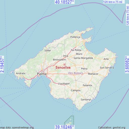
Sencelles GPS coordinates[2]
39° 38' 45.528" North, 2° 53' 51.684" East
| Map corner | latitude | longitude |
|---|---|---|
| Upper-left | 40.18527°, | 2.19457° |
| Center: | 39.64598°, | 2.89769° |
| Lower-right: | 39.10246°, | 3.60082° |
| Map W x H: | 120.4×120.4 km | = 74.8×74.8mi |
| max Lat: | 43.74134° ⇑75.1% North |
| Sencelles: | 39.64598° |
| min Lat: | ⇓24.9% South 27.64134° |
| min Long | Sencelles | max Long |
| -18.00367° | 2.89769° | 4.2899° |
| W 98.1%⇐ | ⇒1.9% E |
Elevation
Elevation of Sencelles is 115 m = 377 ft, and this is 483 m = 1585 ft below average elevation for this country.
| Max E: |
1682 m = 5518 ft | 86.6% |
| Avg. | 598 m = 1962 ft | |
| Sencelles | 115 m = 377 ft | |
Min E: |
0 m = 0 ft | 13.4% |
See also: Spain elevation on elevation.city.
Geographical zone
Sencelles is located in North temperate zone (between Tropic of Cancer and the Arctic Circle). Distance of this Northern Tropic circle is 1802.3 km =1119.9 mi to South.| Distance of | km | miles | from Sencelles |
|---|---|---|---|
| North Pole | 5598.8 | 3478.9 | to North |
| Arctic Circle | 2993 | 1859.8 | to North |
| Tropic Cancer | 1802.3 | 1119.9 | to South |
| Equator | 4408.2 | 2739.1 | to South |


Nearby cities:
15 places around Sencelles: (largest is in red/bold)
• Alaró
11.1 km =6.9 mi,  305°
305°
• Algaida
9.7 km =6 mi,  181°
181°
• Binissalem
6.5 km =4 mi,  315°
315°
• Consell
7.7 km =4.8 mi,  289°
289°
• Costitx
4.6 km =2.9 mi,  74°
74°
• Inca
8.4 km =5.2 mi,  7°
7°
• Lloret de Vistalegre
7.3 km =4.5 mi,  114°
114°
• Lloseta
8.5 km =5.3 mi,  341°
341°
• Llubí
11.1 km =6.9 mi,  57°
57°
• Mancor de la Vall
11.7 km =7.3 mi,  349°
349°
• Montuïri
11.3 km =7 mi,  140°
140°
• Santa Eugènia
5.6 km =3.5 mi,  243°
243°
• Santa Maria del Camí
10.7 km =6.6 mi,  273°
273°
• Selva
12.1 km =7.5 mi,  1°
1°
• Sineu
9.7 km =6 mi,  92°
92°
Sources, notices
• [Note1] Compared only with cities in Spain existing in our database
• [Src1] Map data: © OpenStreetMap contributors (CC-BY-SA)
• [Src2] Other city data from geonames.org with taken over terms of usage.
• [Src3] Geographical zone / Annual Mean Temperature by Robert A. Rohde @ Wikipedia
