Lloret de Vistalegre geodata
Lloret de Vistalegre (Balearic Islands) is a seat of a third-order administrative division; located in Spain in Europe/Madrid (GMT+2) time zone. With population of 1,134 people, there are 2789 cities with bigger population in this country. Compared to other cities in Spain, 75.4% of cities are located further ↑North; 98.5% of cities are located further ←West and 82.8% of cities have higher elevation than Lloret de Vistalegre. Note1
Administrative division(s):
- Level 1: Balearic Islands
- Level 2: Illes Balears
- Level 3: Lloret de Vistalegre


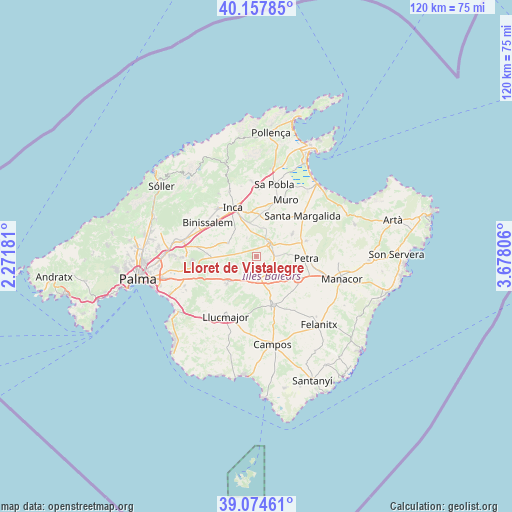
Lloret de Vistalegre GPS coordinates[2]
39° 37' 6.06" North, 2° 58' 29.748" East
| Map corner | latitude | longitude |
|---|---|---|
| Upper-left | 40.15785°, | 2.27181° |
| Center: | 39.61835°, | 2.97493° |
| Lower-right: | 39.07461°, | 3.67806° |
| Map W x H: | 120.4×120.4 km | = 74.8×74.8mi |
| max Lat: | 43.74134° ⇑75.4% North |
| Lloret de Vistalegre: | 39.61835° |
| min Lat: | ⇓24.6% South 27.64134° |
| min Long | Lloret de Vista | max Long |
| -18.00367° | 2.97493° | 4.2899° |
| W 98.5%⇐ | ⇒1.5% E |
Elevation
Elevation of Lloret de Vistalegre is 171 m = 561 ft, and this is 427 m = 1401 ft below average elevation for this country.
| Max E: |
1682 m = 5518 ft | 82.8% |
| Avg. | 598 m = 1962 ft | |
| Lloret de Vistalegre | 171 m = 561 ft | |
Min E: |
0 m = 0 ft | 17.2% |
See also: Spain elevation on elevation.city.
Geographical zone
Lloret de Vistalegre is located in North temperate zone (between Tropic of Cancer and the Arctic Circle). Distance of this Northern Tropic circle is 1799.2 km =1118 mi to South.| Distance of | km | miles | from Lloret de Vistalegre |
|---|---|---|---|
| North Pole | 5601.9 | 3480.9 | to North |
| Arctic Circle | 2996 | 1861.6 | to North |
| Tropic Cancer | 1799.2 | 1118 | to South |
| Equator | 4405.1 | 2737.2 | to South |


Nearby cities:
15 places around Lloret de Vistalegre: (largest is in red/bold)
• Algaida
9.5 km =5.9 mi,  225°
225°
• Ariany
12.2 km =7.6 mi,  72°
72°
• Binissalem
13.6 km =8.5 mi,  304°
304°
• Costitx
4.8 km =3 mi,  333°
333°
• Inca
12.7 km =7.9 mi, 334°
• Llubí
9.4 km =5.8 mi,  16°
16°
• Maria de la Salut
9.8 km =6.1 mi,  59°
59°
• Montuïri
5.7 km =3.5 mi,  173°
173°
• Petra
11.8 km =7.3 mi,  92°
92°
• Porreres
12.2 km =7.6 mi,  160°
160°
• Sant Joan
6 km =3.7 mi,  114°
114°
• Santa Eugènia
11.7 km =7.3 mi,  272°
272°
• Sencelles
7.3 km =4.5 mi,  294°
294°
• Sineu
4.1 km =2.5 mi,  48°
48°
• Vilafranca de Bonany
11.1 km =6.9 mi,  119°
119°
Sources, notices
• [Note1] Compared only with cities in Spain existing in our database
• [Src1] Map data: © OpenStreetMap contributors (CC-BY-SA)
• [Src2] Other city data from geonames.org with taken over terms of usage.
• [Src3] Geographical zone / Annual Mean Temperature by Robert A. Rohde @ Wikipedia
