Llubí geodata
Llubí (Balearic Islands) is a seat of a third-order administrative division; located in Spain in Europe/Madrid (GMT+2) time zone. With population of 2,030 people, there are 2146 cities with bigger population in this country. Compared to other cities in Spain, 74.5% of cities are located further ↑North; 98.7% of cities are located further ←West and 90.6% of cities have higher elevation than Llubí. Note1


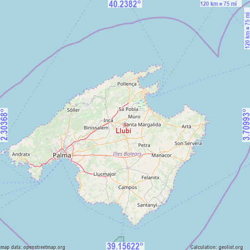
Llubí GPS coordinates[2]
39° 41' 57.588" North, 3° 0' 24.516" East
| Map corner | latitude | longitude |
|---|---|---|
| Upper-left | 40.2382°, | 2.30368° |
| Center: | 39.69933°, | 3.00681° |
| Lower-right: | 39.15622°, | 3.70993° |
| Map W x H: | 120.3×120.3 km | = 74.8×74.8mi |
| max Lat: | 43.74134° ⇑74.5% North |
| Llubí: | 39.69933° |
| min Lat: | ⇓25.5% South 27.64134° |
| min Long | Llubí | max Long |
| -18.00367° | 3.00681° | 4.2899° |
| W 98.7%⇐ | ⇒1.3% E |
Elevation
Elevation of Llubí is 56 m = 184 ft, and this is 542 m = 1778 ft below average elevation for this country.
| Max E: |
1682 m = 5518 ft | 90.6% |
| Avg. | 598 m = 1962 ft | |
| Llubí | 56 m = 184 ft | |
Min E: |
0 m = 0 ft | 9.4% |
See also: Spain elevation on elevation.city.
Geographical zone
Llubí is located in North temperate zone (between Tropic of Cancer and the Arctic Circle). Distance of this Northern Tropic circle is 1808.2 km =1123.6 mi to South.| Distance of | km | miles | from Llubí |
|---|---|---|---|
| North Pole | 5592.9 | 3475.3 | to North |
| Arctic Circle | 2987 | 1856 | to North |
| Tropic Cancer | 1808.2 | 1123.6 | to South |
| Equator | 4414.2 | 2742.9 | to South |


Nearby cities:
15 places around Llubí: (largest is in red/bold)
• Ariany
10.4 km =6.5 mi,  121°
121°
• Búger
6.8 km =4.2 mi,  343°
343°
• Campanet
9.1 km =5.7 mi, 336°
• Costitx
6.8 km =4.2 mi,  225°
225°
• Inca
8.6 km =5.3 mi,  286°
286°
• Lloret de Vistalegre
9.4 km =5.8 mi,  196°
196°
• Lloseta
12.2 km =7.6 mi,  280°
280°
• Maria de la Salut
7 km =4.3 mi,  125°
125°
• Muro
5.9 km =3.7 mi,  45°
45°
• Sant Joan
11.8 km =7.3 mi,  166°
166°
• Santa Margalida
8.2 km =5.1 mi,  88°
88°
• Selva
11 km =6.8 mi,  304°
304°
• Sencelles
11.1 km =6.9 mi,  237°
237°
• Sineu
6.3 km =3.9 mi,  177°
177°
• sa Pobla
7.9 km =4.9 mi,  10°
10°
Sources, notices
• [Note1] Compared only with cities in Spain existing in our database
• [Src1] Map data: © OpenStreetMap contributors (CC-BY-SA)
• [Src2] Other city data from geonames.org with taken over terms of usage.
• [Src3] Geographical zone / Annual Mean Temperature by Robert A. Rohde @ Wikipedia
