Salobre geodata
Salobre (Castille-La Mancha) is a seat of a third-order administrative division; located in Spain in Europe/Madrid (GMT+2) time zone. With population of 621 people, there are 3565 cities with bigger population in this country. Compared to other cities in Spain, 85.1% of cities are located further ↑North; 60.4% of cities are located further ←West and 82.4% of cities have lower elevation than Salobre. Note1
Administrative division(s):
- Level 1: Castille-La Mancha
- Level 2: Provincia de Albacete
- Level 3: Salobre


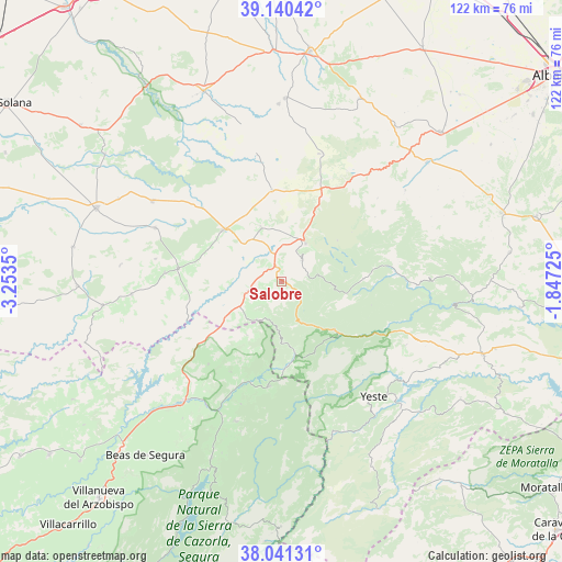
Salobre GPS coordinates[2]
38° 35' 34.692" North, 2° 33' 1.368" West
| Map corner | latitude | longitude |
|---|---|---|
| Upper-left | 39.14042°, | -3.2535° |
| Center: | 38.59297°, | -2.55038° |
| Lower-right: | 38.04131°, | -1.84725° |
| Map W x H: | 122.2×122.2 km | = 75.9×75.9mi |
| max Lat: | 43.74134° ⇑85.1% North |
| Salobre: | 38.59297° |
| min Lat: | ⇓14.9% South 27.64134° |
| min Long | Salobre | max Long |
| -18.00367° | -2.55038° | 4.2899° |
| W 60.4%⇐ | ⇒39.6% E |
Elevation
Elevation of Salobre is 921 m = 3022 ft, and this is 323 m = 1060 ft above average elevation for this country.
| Max E: |
1682 m = 5518 ft | 17.6% |
| Salobre | 921 m 3022 ft | |
| Avg. | 598 m = 1962 ft | |
Min E: |
0 m = 0 ft | 82.4% |
See also: Spain elevation on elevation.city.
Geographical zone
Salobre is located in North temperate zone (between Tropic of Cancer and the Arctic Circle). Distance of this Northern Tropic circle is 1685.2 km =1047.1 mi to South.| Distance of | km | miles | from Salobre |
|---|---|---|---|
| North Pole | 5715.9 | 3551.7 | to North |
| Arctic Circle | 3110 | 1932.5 | to North |
| Tropic Cancer | 1685.2 | 1047.1 | to South |
| Equator | 4291.1 | 2666.4 | to South |


Nearby cities:
15 places around Salobre: (largest is in red/bold)
• Albaladejo
22.6 km =14 mi,  277°
277°
• Alcaraz
9.7 km =6 mi,  32°
32°
• Bienservida
9.9 km =6.2 mi,  211°
211°
• Cotillas
18.4 km =11.4 mi,  167°
167°
• Génave
24.1 km =15 mi,  221°
221°
• Paterna del Madera
17.9 km =11.1 mi,  88°
88°
• Povedilla
12.7 km =7.9 mi,  339°
339°
• Riópar
13.5 km =8.4 mi,  139°
139°
• Robledo
20.3 km =12.6 mi, 25°
• Siles
22.8 km =14.2 mi,  186°
186°
• Torres de Albanchez
22.6 km =14 mi, 209°
• Villanueva de la Fuente
17 km =10.6 mi,  311°
311°
• Villapalacios
7.5 km =4.7 mi,  254°
254°
• Villaverde de Guadalimar
15.6 km =9.7 mi, 169°
• Viveros
20.1 km =12.5 mi,  354°
354°
Sources, notices
• [Note1] Compared only with cities in Spain existing in our database
• [Src1] Map data: © OpenStreetMap contributors (CC-BY-SA)
• [Src2] Other city data from geonames.org with taken over terms of usage.
• [Src3] Geographical zone / Annual Mean Temperature by Robert A. Rohde @ Wikipedia
