Albaladejo geodata
Albaladejo (Castille-La Mancha) is a seat of a third-order administrative division; located in Spain in Europe/Madrid (GMT+2) time zone. With population of 1,570 people, there are 2409 cities with bigger population in this country. Compared to other cities in Spain, 84.8% of cities are located further ↑North; 57.3% of cities are located further ←West and 82.7% of cities have lower elevation than Albaladejo. Note1
Administrative division(s):
- Level 1: Castille-La Mancha
- Level 2: Provincia de Ciudad Real
- Level 3: Albaladejo


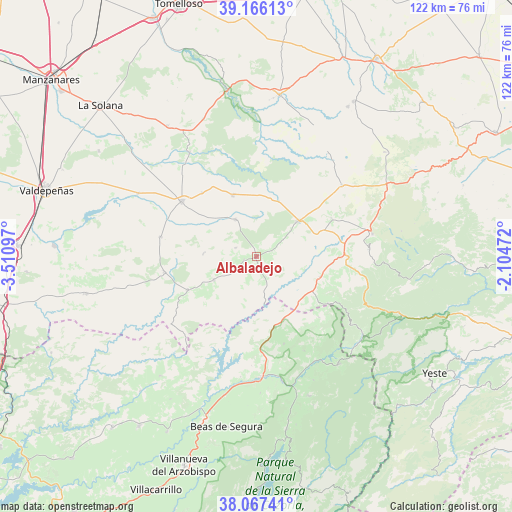
Albaladejo GPS coordinates[2]
38° 37' 7.932" North, 2° 48' 28.224" West
| Map corner | latitude | longitude |
|---|---|---|
| Upper-left | 39.16613°, | -3.51097° |
| Center: | 38.61887°, | -2.80784° |
| Lower-right: | 38.06741°, | -2.10472° |
| Map W x H: | 122.2×122.2 km | = 75.9×75.9mi |
| max Lat: | 43.74134° ⇑84.8% North |
| Albaladejo: | 38.61887° |
| min Lat: | ⇓15.2% South 27.64134° |
| min Long | Albaladejo | max Long |
| -18.00367° | -2.80784° | 4.2899° |
| W 57.3%⇐ | ⇒42.7% E |
Elevation
Elevation of Albaladejo is 924 m = 3031 ft, and this is 326 m = 1070 ft above average elevation for this country.
| Max E: |
1682 m = 5518 ft | 17.3% |
| Albaladejo | 924 m 3031 ft | |
| Avg. | 598 m = 1962 ft | |
Min E: |
0 m = 0 ft | 82.7% |
See also: Spain elevation on elevation.city.
Geographical zone
Albaladejo is located in North temperate zone (between Tropic of Cancer and the Arctic Circle). Distance of this Northern Tropic circle is 1688.1 km =1048.9 mi to South.| Distance of | km | miles | from Albaladejo |
|---|---|---|---|
| North Pole | 5713 | 3549.9 | to North |
| Arctic Circle | 3107.2 | 1930.7 | to North |
| Tropic Cancer | 1688.1 | 1048.9 | to South |
| Equator | 4294 | 2668.2 | to South |


Nearby cities:
15 places around Albaladejo: (largest is in red/bold)
• Almedina
12.7 km =7.9 mi,  272°
272°
• Bienservida
20.5 km =12.7 mi,  123°
123°
• Fuenllana
20.1 km =12.5 mi,  319°
319°
• Génave
21.9 km =13.6 mi,  162°
162°
• Infantes
22.1 km =13.7 mi,  306°
306°
• Montiel
10.1 km =6.3 mi,  330°
330°
• Povedilla
20 km =12.4 mi,  63°
63°
• Puebla del Príncipe
11.7 km =7.3 mi,  241°
241°
• Santa Cruz de los Cáñamos
5.5 km =3.4 mi,  292°
292°
• Terrinches
3.1 km =1.9 mi,  252°
252°
• Torre de Juan Abad
22.2 km =13.8 mi,  260°
260°
• Villahermosa
15.6 km =9.7 mi,  339°
339°
• Villamanrique
18.3 km =11.4 mi, 243°
• Villanueva de la Fuente
12.8 km =8 mi,  48°
48°
• Villapalacios
15.9 km =9.9 mi,  107°
107°
Sources, notices
• [Note1] Compared only with cities in Spain existing in our database
• [Src1] Map data: © OpenStreetMap contributors (CC-BY-SA)
• [Src2] Other city data from geonames.org with taken over terms of usage.
• [Src3] Geographical zone / Annual Mean Temperature by Robert A. Rohde @ Wikipedia
