Génave geodata
Génave (Andalusia) is a seat of a third-order administrative division; located in Spain in Europe/Madrid (GMT+2) time zone. With population of 592 people, there are 3630 cities with bigger population in this country. Compared to other cities in Spain, 86% of cities are located further ↑North; 58.3% of cities are located further ←West and 70.9% of cities have lower elevation than Génave. Note1


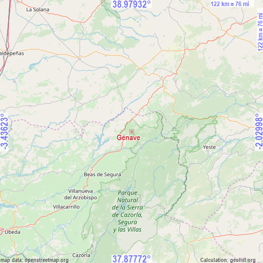
Génave GPS coordinates[2]
38° 25' 50.232" North, 2° 43' 59.16" West
| Map corner | latitude | longitude |
|---|---|---|
| Upper-left | 38.97932°, | -3.43623° |
| Center: | 38.43062°, | -2.7331° |
| Lower-right: | 37.87772°, | -2.02998° |
| Map W x H: | 122.5×122.5 km | = 76.1×76.1mi |
| max Lat: | 43.74134° ⇑86% North |
| Génave: | 38.43062° |
| min Lat: | ⇓14% South 27.64134° |
| min Long | Génave | max Long |
| -18.00367° | -2.7331° | 4.2899° |
| W 58.3%⇐ | ⇒41.7% E |
Elevation
Elevation of Génave is 820 m = 2690 ft, and this is 222 m = 728 ft above average elevation for this country.
| Max E: |
1682 m = 5518 ft | 29.1% |
| Génave | 820 m 2690 ft | |
| Avg. | 598 m = 1962 ft | |
Min E: |
0 m = 0 ft | 70.9% |
See also: Spain elevation on elevation.city.
Geographical zone
Génave is located in North temperate zone (between Tropic of Cancer and the Arctic Circle). Distance of this Northern Tropic circle is 1667.2 km =1035.9 mi to South.| Distance of | km | miles | from Génave |
|---|---|---|---|
| North Pole | 5734 | 3562.9 | to North |
| Arctic Circle | 3128.1 | 1943.7 | to North |
| Tropic Cancer | 1667.2 | 1035.9 | to South |
| Equator | 4273.1 | 2655.2 | to South |


Nearby cities:
15 places around Génave: (largest is in red/bold)
• Albaladejo
21.9 km =13.6 mi,  342°
342°
• Arroyo del Ojanco
18.7 km =11.6 mi,  229°
229°
• Benatae
11.2 km =7 mi,  140°
140°
• Bienservida
14.3 km =8.9 mi,  47°
47°
• Cotillas
19.8 km =12.3 mi,  89°
89°
• La Puerta de Segura
8.7 km =5.4 mi,  183°
183°
• Orcera
13.9 km =8.6 mi,  154°
154°
• Puebla del Príncipe
22.7 km =14.1 mi,  312°
312°
• Puente de Génave
10.4 km =6.5 mi,  216°
216°
• Segura de la Sierra
16.4 km =10.2 mi, 154°
• Siles
13.9 km =8.6 mi,  108°
108°
• Terrinches
22.1 km =13.7 mi,  334°
334°
• Torres de Albanchez
5.1 km =3.2 mi, 109°
• Villapalacios
18.2 km =11.3 mi,  28°
28°
• Villaverde de Guadalimar
18.9 km =11.7 mi,  81°
81°
Sources, notices
• [Note1] Compared only with cities in Spain existing in our database
• [Src1] Map data: © OpenStreetMap contributors (CC-BY-SA)
• [Src2] Other city data from geonames.org with taken over terms of usage.
• [Src3] Geographical zone / Annual Mean Temperature by Robert A. Rohde @ Wikipedia
