Sacañet geodata
Sacañet (Valencia) is a seat of a third-order administrative division; located in Spain in Europe/Madrid (GMT+2) time zone. With population of 147 people, there are 5452 cities with bigger population in this country. Compared to other cities in Spain, 72.2% of cities are located further ↑North; 79.7% of cities are located further ←West and 90.8% of cities have lower elevation than Sacañet. Note1


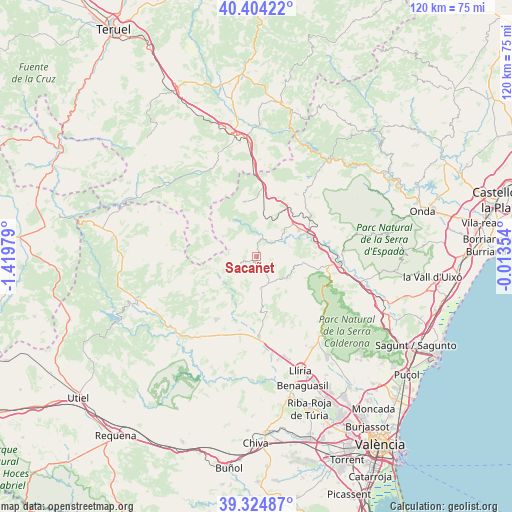
Sacañet GPS coordinates[2]
39° 52' 0.012" North, 0° 43' 0.012" West
| Map corner | latitude | longitude |
|---|---|---|
| Upper-left | 40.40422°, | -1.41979° |
| Center: | 39.86667°, | -0.71667° |
| Lower-right: | 39.32487°, | -0.01354° |
| Map W x H: | 120×120 km | = 74.6×74.6mi |
| max Lat: | 43.74134° ⇑72.2% North |
| Sacañet: | 39.86667° |
| min Lat: | ⇓27.8% South 27.64134° |
| min Long | Sacañet | max Long |
| -18.00367° | -0.71667° | 4.2899° |
| W 79.7%⇐ | ⇒20.3% E |
Elevation
Elevation of Sacañet is 1046 m = 3432 ft, and this is 448 m = 1470 ft above average elevation for this country.
| Max E: |
1682 m = 5518 ft | 9.2% |
| Sacañet | 1046 m 3432 ft | |
| Avg. | 598 m = 1962 ft | |
Min E: |
0 m = 0 ft | 90.8% |
See also: Spain elevation on elevation.city.
Geographical zone
Sacañet is located in North temperate zone (between Tropic of Cancer and the Arctic Circle). Distance of this Northern Tropic circle is 1826.8 km =1135.1 mi to South.| Distance of | km | miles | from Sacañet |
|---|---|---|---|
| North Pole | 5574.3 | 3463.7 | to North |
| Arctic Circle | 2968.4 | 1844.5 | to North |
| Tropic Cancer | 1826.8 | 1135.1 | to South |
| Equator | 4432.8 | 2754.4 | to South |


Nearby cities:
15 places around Sacañet: (largest is in red/bold)
• Alcublas
7.5 km =4.7 mi,  169°
169°
• Altura
17.2 km =10.7 mi,  96°
96°
• Andilla
8 km =5 mi,  242°
242°
• Barracas
16.9 km =10.5 mi,  9°
9°
• Casinos
18.6 km =11.6 mi,  175°
175°
• Caudiel
15.8 km =9.8 mi,  54°
54°
• Higueruelas
14.7 km =9.1 mi,  230°
230°
• Jérica
14 km =8.7 mi,  66°
66°
• La Yesa
20 km =12.4 mi,  275°
275°
• Navajas
18.6 km =11.6 mi,  84°
84°
• Pina de Montalgrao
17.6 km =10.9 mi,  18°
18°
• Segorbe
20 km =12.4 mi, 95°
• Torás
6.2 km =3.9 mi,  27°
27°
• Villar del Arzobispo
17.1 km =10.6 mi,  209°
209°
• Viver
11.4 km =7.1 mi,  60°
60°
Sources, notices
• [Note1] Compared only with cities in Spain existing in our database
• [Src1] Map data: © OpenStreetMap contributors (CC-BY-SA)
• [Src2] Other city data from geonames.org with taken over terms of usage.
• [Src3] Geographical zone / Annual Mean Temperature by Robert A. Rohde @ Wikipedia
