Barracas geodata
Barracas (Valencia) is a seat of a third-order administrative division; located in Spain in Europe/Madrid (GMT+2) time zone. With population of 183 people, there are 5165 cities with bigger population in this country. Compared to other cities in Spain, 70% of cities are located further ↑North; 80% of cities are located further ←West and 89.1% of cities have lower elevation than Barracas. Note1


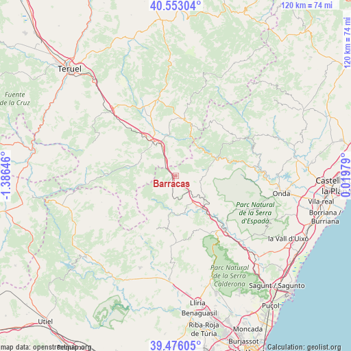
Barracas GPS coordinates[2]
40° 1' 0.012" North, 0° 40' 59.988" West
| Map corner | latitude | longitude |
|---|---|---|
| Upper-left | 40.55304°, | -1.38646° |
| Center: | 40.01667°, | -0.68333° |
| Lower-right: | 39.47605°, | 0.01979° |
| Map W x H: | 119.8×119.7 km | = 74.4×74.4mi |
| max Lat: | 43.74134° ⇑70% North |
| Barracas: | 40.01667° |
| min Lat: | ⇓30% South 27.64134° |
| min Long | Barracas | max Long |
| -18.00367° | -0.68333° | 4.2899° |
| W 80%⇐ | ⇒20% E |
Elevation
Elevation of Barracas is 1018 m = 3340 ft, and this is 420 m = 1378 ft above average elevation for this country.
| Max E: |
1682 m = 5518 ft | 10.9% |
| Barracas | 1018 m 3340 ft | |
| Avg. | 598 m = 1962 ft | |
Min E: |
0 m = 0 ft | 89.1% |
See also: Spain elevation on elevation.city.
Geographical zone
Barracas is located in North temperate zone (between Tropic of Cancer and the Arctic Circle). Distance of this Northern Tropic circle is 1843.5 km =1145.5 mi to South.| Distance of | km | miles | from Barracas |
|---|---|---|---|
| North Pole | 5557.6 | 3453.3 | to North |
| Arctic Circle | 2951.7 | 1834.1 | to North |
| Tropic Cancer | 1843.5 | 1145.5 | to South |
| Equator | 4449.4 | 2764.7 | to South |


Nearby cities:
15 places around Barracas: (largest is in red/bold)
• Albentosa
12 km =7.5 mi,  323°
323°
• Caudiel
12.4 km =7.7 mi,  126°
126°
• Fuente la Reina
9 km =5.6 mi,  51°
51°
• Higueras
16 km =9.9 mi,  103°
103°
• Jérica
14.9 km =9.3 mi,  138°
138°
• Manzanera
13.3 km =8.3 mi,  286°
286°
• Montanejos
15.2 km =9.4 mi,  68°
68°
• Montán
11.5 km =7.1 mi,  80°
80°
• Olba
14.2 km =8.8 mi,  23°
23°
• Pina de Montalgrao
2.8 km =1.7 mi,  90°
90°
• Puebla de Arenoso
12.6 km =7.8 mi,  42°
42°
• San Agustín
4.8 km =3 mi,  350°
350°
• Torás
11.1 km =6.9 mi,  180°
180°
• Villanueva de Viver
4.7 km =2.9 mi, 37°
• Viver
13.2 km =8.2 mi,  147°
147°
Sources, notices
• [Note1] Compared only with cities in Spain existing in our database
• [Src1] Map data: © OpenStreetMap contributors (CC-BY-SA)
• [Src2] Other city data from geonames.org with taken over terms of usage.
• [Src3] Geographical zone / Annual Mean Temperature by Robert A. Rohde @ Wikipedia
