Puig geodata
Puig (Valencia) is a seat of a third-order administrative division; located in Spain in Europe/Madrid (GMT+2) time zone. With population of 7,851 people, there are 952 cities with bigger population in this country. Compared to other cities in Spain, 75.9% of cities are located further ↑North; 84.5% of cities are located further ←West and 97.6% of cities have higher elevation than Puig. Note1
Administrative division(s):
- Level 1: Valencia
- Level 2: Província de València
- Level 3: Puig de Santa Maria, el


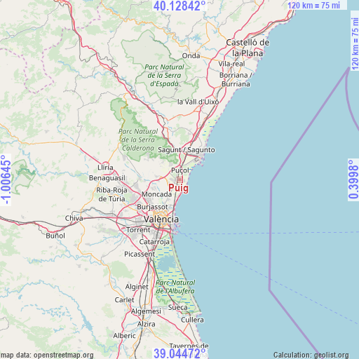
Puig GPS coordinates[2]
39° 35' 19.284" North, 0° 18' 11.988" West
| Map corner | latitude | longitude |
|---|---|---|
| Upper-left | 40.12842°, | -1.00645° |
| Center: | 39.58869°, | -0.30333° |
| Lower-right: | 39.04472°, | 0.3998° |
| Map W x H: | 120.5×120.5 km | = 74.9×74.9mi |
| max Lat: | 43.74134° ⇑75.9% North |
| Puig: | 39.58869° |
| min Lat: | ⇓24.1% South 27.64134° |
| min Long | Puig | max Long |
| -18.00367° | -0.30333° | 4.2899° |
| W 84.5%⇐ | ⇒15.5% E |
Elevation
Elevation of Puig is 13 m = 43 ft, and this is 585 m = 1919 ft below average elevation for this country.
| Max E: |
1682 m = 5518 ft | 97.6% |
| Avg. | 598 m = 1962 ft | |
| Puig | 13 m = 43 ft | |
Min E: |
0 m = 0 ft | 2.4% |
See also: Spain elevation on elevation.city.
Geographical zone
Puig is located in North temperate zone (between Tropic of Cancer and the Arctic Circle). Distance of this Northern Tropic circle is 1795.9 km =1115.9 mi to South.| Distance of | km | miles | from Puig |
|---|---|---|---|
| North Pole | 5605.2 | 3482.9 | to North |
| Arctic Circle | 2999.3 | 1863.7 | to North |
| Tropic Cancer | 1795.9 | 1115.9 | to South |
| Equator | 4401.8 | 2735.2 | to South |


Nearby cities:
15 places around Puig: (largest is in red/bold)
• Albalat dels Sorells
7.3 km =4.5 mi,  213°
213°
• Albuixech
4.5 km =2.8 mi,  194°
194°
• Alfara del Patriarca
8.1 km =5 mi,  237°
237°
• Bonrepòs i Mirambell
9.7 km =6 mi, 214°
• Emperador
5 km =3.1 mi, 210°
• Foios
7.3 km =4.5 mi, 213°
• Grao de Murviedro
8.1 km =5 mi,  43°
43°
• La Pobla de Farnals
3 km =1.9 mi,  147°
147°
• Massamagrell
3.6 km =2.2 mi,  226°
226°
• Meliana
6.7 km =4.2 mi,  202°
202°
• Moncada
9.2 km =5.7 mi, 238°
• Museros
4.7 km =2.9 mi, 238°
• Puçol
3.1 km =1.9 mi,  5°
5°
• Rocafort
10.3 km =6.4 mi, 233°
• Vinalesa
8.2 km =5.1 mi,  221°
221°
Sources, notices
• [Note1] Compared only with cities in Spain existing in our database
• [Src1] Map data: © OpenStreetMap contributors (CC-BY-SA)
• [Src2] Other city data from geonames.org with taken over terms of usage.
• [Src3] Geographical zone / Annual Mean Temperature by Robert A. Rohde @ Wikipedia
