Puçol geodata
Puçol (Valencia) is a seat of a third-order administrative division; located in Spain in Europe/Madrid (GMT+2) time zone. With population of 19,018 people, there are 496 cities with bigger population in this country. Compared to other cities in Spain, 75.5% of cities are located further ↑North; 84.5% of cities are located further ←West and 98.4% of cities have higher elevation than Puçol. Note1


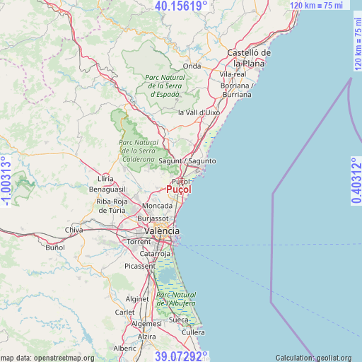
Puçol GPS coordinates[2]
39° 37' 0.012" North, 0° 18' 0" West
| Map corner | latitude | longitude |
|---|---|---|
| Upper-left | 40.15619°, | -1.00313° |
| Center: | 39.61667°, | -0.3° |
| Lower-right: | 39.07292°, | 0.40312° |
| Map W x H: | 120.4×120.4 km | = 74.8×74.8mi |
| max Lat: | 43.74134° ⇑75.5% North |
| Puçol: | 39.61667° |
| min Lat: | ⇓24.5% South 27.64134° |
| min Long | Puçol | max Long |
| -18.00367° | -0.3° | 4.2899° |
| W 84.5%⇐ | ⇒15.5% E |
Elevation
Elevation of Puçol is 10 m = 33 ft, and this is 588 m = 1929 ft below average elevation for this country.
| Max E: |
1682 m = 5518 ft | 98.4% |
| Avg. | 598 m = 1962 ft | |
| Puçol | 10 m = 33 ft | |
Min E: |
0 m = 0 ft | 1.6% |
See also: Spain elevation on elevation.city.
Geographical zone
Puçol is located in North temperate zone (between Tropic of Cancer and the Arctic Circle). Distance of this Northern Tropic circle is 1799 km =1117.8 mi to South.| Distance of | km | miles | from Puçol |
|---|---|---|---|
| North Pole | 5602.1 | 3481 | to North |
| Arctic Circle | 2996.2 | 1861.8 | to North |
| Tropic Cancer | 1799 | 1117.8 | to South |
| Equator | 4405 | 2737.1 | to South |


Nearby cities:
15 places around Puçol: (largest is in red/bold)
• Albalat dels Sorells
10.2 km =6.3 mi,  204°
204°
• Albalat dels Tarongers
9.7 km =6 mi,  342°
342°
• Albuixech
7.5 km =4.7 mi,  190°
190°
• Emperador
7.9 km =4.9 mi, 201°
• Foios
10.2 km =6.3 mi, 204°
• Gilet
7.5 km =4.7 mi,  349°
349°
• Grao de Murviedro
5.9 km =3.7 mi,  62°
62°
• La Pobla de Farnals
5.8 km =3.6 mi,  166°
166°
• Massamagrell
6.3 km =3.9 mi,  207°
207°
• Meliana
9.7 km =6 mi, 197°
• Museros
7 km =4.3 mi,  217°
217°
• Petrés
7.4 km =4.6 mi,  0°
0°
• Puig
3.1 km =1.9 mi, 185°
• Sagunto
7.9 km =4.9 mi,  21°
21°
• Segart
9.4 km =5.8 mi,  322°
322°
Sources, notices
• [Note1] Compared only with cities in Spain existing in our database
• [Src1] Map data: © OpenStreetMap contributors (CC-BY-SA)
• [Src2] Other city data from geonames.org with taken over terms of usage.
• [Src3] Geographical zone / Annual Mean Temperature by Robert A. Rohde @ Wikipedia
