Grao de Murviedro geodata
Grao de Murviedro (Valencia) is a populated place; located in Spain in Europe/Madrid (GMT+2) time zone. With population of 62,368 people, there are 151 cities with bigger population in this country. Compared to other cities in Spain, 75.2% of cities are located further ↑North; 85.2% of cities are located further ←West and 99.8% of cities have higher elevation than Grao de Murviedro. Note1
Administrative division(s):
- Level 1: Valencia
- Level 2: Província de València
- Level 3: Sagunto/Sagunt


Grao de Murviedro GPS coordinates[2]
39° 38' 30.012" North, 0° 14' 20.004" West
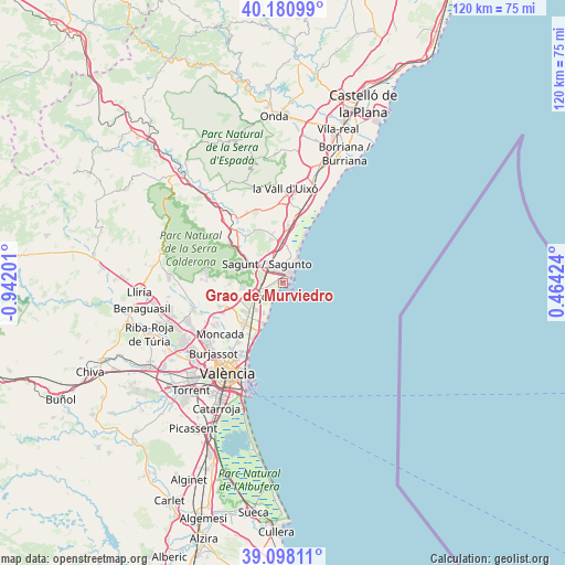
| Map corner | latitude | longitude |
|---|---|---|
| Upper-left | 40.18099°, | -0.94201° |
| Center: | 39.64167°, | -0.23889° |
| Lower-right: | 39.09811°, | 0.46424° |
| Map W x H: | 120.4×120.4 km | = 74.8×74.8mi |
| max Lat: | 43.74134° ⇑75.2% North |
| Grao de Murviedro: | 39.64167° |
| min Lat: | ⇓24.8% South 27.64134° |
| min Long | Grao de Murvied | max Long |
| -18.00367° | -0.23889° | 4.2899° |
| W 85.2%⇐ | ⇒14.8% E |
Elevation
Elevation of Grao de Murviedro is 3 m = 10 ft, and this is 595 m = 1952 ft below average elevation for this country.
| Max E: |
1682 m = 5518 ft | 99.8% |
| Avg. | 598 m = 1962 ft | |
| Grao de Murviedro | 3 m = 10 ft | |
Min E: |
0 m = 0 ft | 0.2% |
See also: Grao de Murviedro elevation on elevation.city.
Geographical zone
Grao de Murviedro is located in North temperate zone (between Tropic of Cancer and the Arctic Circle). Distance of this Northern Tropic circle is 1801.8 km =1119.6 mi to South.| Distance of | km | miles | from Grao de Murviedro |
|---|---|---|---|
| North Pole | 5599.3 | 3479.2 | to North |
| Arctic Circle | 2993.4 | 1860 | to North |
| Tropic Cancer | 1801.8 | 1119.6 | to South |
| Equator | 4407.7 | 2738.8 | to South |


Nearby cities:
15 places around Grao de Murviedro: (largest is in red/bold)
• Albalat dels Tarongers
10.4 km =6.5 mi,  308°
308°
• Benavites
10.2 km =6.3 mi,  354°
354°
• Benifairó de les Valls
10.5 km =6.5 mi, 346°
• Canet d'En Berenguer
5 km =3.1 mi,  22°
22°
• Faura
8.4 km =5.2 mi, 353°
• Gilet
8.1 km =5 mi,  304°
304°
• La Pobla de Farnals
9.3 km =5.8 mi,  204°
204°
• Massamagrell
11.6 km =7.2 mi,  224°
224°
• Petrés
7 km =4.3 mi, 311°
• Puig
8.1 km =5 mi, 223°
• Puçol
5.9 km =3.7 mi,  242°
242°
• Quart de les Valls
10.5 km =6.5 mi, 346°
• Quartell
10.9 km =6.8 mi, 348°
• Sagunto
5.2 km =3.2 mi,  332°
332°
• Segart
11.9 km =7.4 mi,  292°
292°
Sources, notices
• [Note1] Compared only with cities in Spain existing in our database
• [Src1] Map data: © OpenStreetMap contributors (CC-BY-SA)
• [Src2] Other city data from geonames.org with taken over terms of usage.
• [Src3] Geographical zone / Annual Mean Temperature by Robert A. Rohde @ Wikipedia
