Puertollano geodata
Puertollano (Castille-La Mancha) is a seat of a third-order administrative division; located in Spain in Europe/Madrid (GMT+2) time zone. With population of 51,842 people, there are 177 cities with bigger population in this country. Compared to other cities in Spain, 84.4% of cities are located further ↑North; 61.3% of cities are located further →East and 54.1% of cities have lower elevation than Puertollano. Note1
Administrative division(s):
- Level 1: Castille-La Mancha
- Level 2: Provincia de Ciudad Real
- Level 3: Puertollano


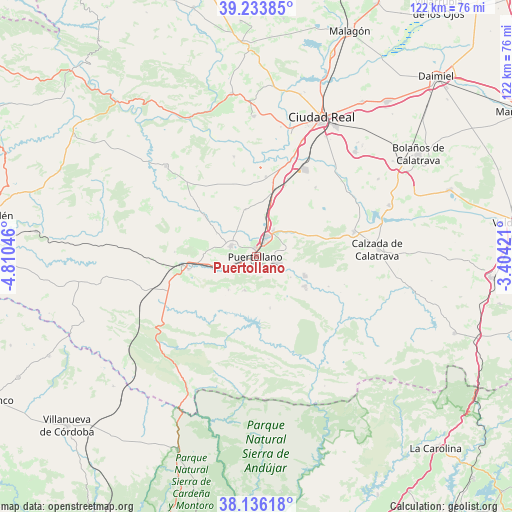
Puertollano GPS coordinates[2]
38° 41' 13.632" North, 4° 6' 26.424" West
| Map corner | latitude | longitude |
|---|---|---|
| Upper-left | 39.23385°, | -4.81046° |
| Center: | 38.68712°, | -4.10734° |
| Lower-right: | 38.13618°, | -3.40421° |
| Map W x H: | 122×122 km | = 75.8×75.8mi |
| max Lat: | 43.74134° ⇑84.4% North |
| Puertollano: | 38.68712° |
| min Lat: | ⇓15.6% South 27.64134° |
| min Long | Puertollano | max Long |
| -18.00367° | -4.10734° | 4.2899° |
| W 38.7%⇐ | ⇒61.3% E |
Elevation
Elevation of Puertollano is 701 m = 2300 ft, and this is 103 m = 338 ft above average elevation for this country.
| Max E: |
1682 m = 5518 ft | 45.9% |
| Puertollano | 701 m 2300 ft | |
| Avg. | 598 m = 1962 ft | |
Min E: |
0 m = 0 ft | 54.1% |
See also: Puertollano elevation on elevation.city.
Geographical zone
Puertollano is located in North temperate zone (between Tropic of Cancer and the Arctic Circle). Distance of this Northern Tropic circle is 1695.7 km =1053.7 mi to South.| Distance of | km | miles | from Puertollano |
|---|---|---|---|
| North Pole | 5705.5 | 3545.2 | to North |
| Arctic Circle | 3099.6 | 1926 | to North |
| Tropic Cancer | 1695.7 | 1053.7 | to South |
| Equator | 4301.6 | 2672.9 | to South |


Nearby cities:
15 places around Puertollano: (largest is in red/bold)
• Aldea del Rey
23.9 km =14.9 mi,  76°
76°
• Almodóvar del Campo
6.7 km =4.2 mi,  291°
291°
• Argamasilla de Calatrava
5.5 km =3.4 mi,  29°
29°
• Ballesteros de Calatrava
21.6 km =13.4 mi,  40°
40°
• Brazatortas
16.5 km =10.3 mi,  258°
258°
• Cabezarados
24.1 km =15 mi,  316°
316°
• Cabezarrubias del Puerto
10.4 km =6.5 mi,  219°
219°
• Cañada de Calatrava
20 km =12.4 mi,  21°
21°
• Corral de Calatrava
19.1 km =11.9 mi,  6°
6°
• Hinojosas de Calatrava
8.6 km =5.3 mi,  199°
199°
• Mestanza
12.7 km =7.9 mi,  165°
165°
• Pozuelo de Calatrava
26.4 km =16.4 mi,  115°
115°
• Villamayor de Calatrava
11.5 km =7.1 mi,  346°
346°
• Villanueva de San Carlos
18.7 km =11.6 mi,  112°
112°
• Villar del Pozo
22 km =13.7 mi, 34°
Sources, notices
• [Note1] Compared only with cities in Spain existing in our database
• [Src1] Map data: © OpenStreetMap contributors (CC-BY-SA)
• [Src2] Other city data from geonames.org with taken over terms of usage.
• [Src3] Geographical zone / Annual Mean Temperature by Robert A. Rohde @ Wikipedia
