Corral de Calatrava geodata
Corral de Calatrava (Castille-La Mancha) is a seat of a third-order administrative division; located in Spain in Europe/Madrid (GMT+2) time zone. With population of 1,261 people, there are 2672 cities with bigger population in this country. Compared to other cities in Spain, 82.5% of cities are located further ↑North; 61% of cities are located further →East and 54.9% of cities have higher elevation than Corral de Calatrava. Note1
Administrative division(s):
- Level 1: Castille-La Mancha
- Level 2: Provincia de Ciudad Real
- Level 3: Corral de Calatrava


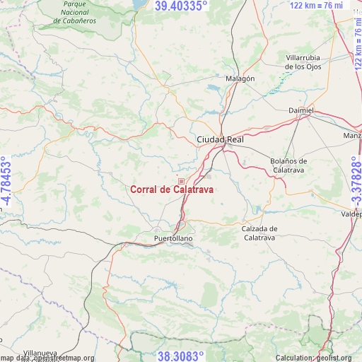
Corral de Calatrava GPS coordinates[2]
38° 51' 28.548" North, 4° 4' 53.04" West
| Map corner | latitude | longitude |
|---|---|---|
| Upper-left | 39.40335°, | -4.78453° |
| Center: | 38.85793°, | -4.0814° |
| Lower-right: | 38.3083°, | -3.37828° |
| Map W x H: | 121.8×121.8 km | = 75.7×75.7mi |
| max Lat: | 43.74134° ⇑82.5% North |
| Corral de Calatrava: | 38.85793° |
| min Lat: | ⇓17.5% South 27.64134° |
| min Long | Corral de Calat | max Long |
| -18.00367° | -4.0814° | 4.2899° |
| W 39%⇐ | ⇒61% E |
Elevation
Elevation of Corral de Calatrava is 596 m = 1955 ft, and this is 2 m = 7 ft below average elevation for this country.
| Max E: |
1682 m = 5518 ft | 54.9% |
| Avg. | 598 m = 1962 ft | |
| Corral de Calatrava | 596 m = 1955 ft | |
Min E: |
0 m = 0 ft | 45.1% |
See also: Spain elevation on elevation.city.
Geographical zone
Corral de Calatrava is located in North temperate zone (between Tropic of Cancer and the Arctic Circle). Distance of this Northern Tropic circle is 1714.7 km =1065.5 mi to South.| Distance of | km | miles | from Corral de Calatrava |
|---|---|---|---|
| North Pole | 5686.5 | 3533.4 | to North |
| Arctic Circle | 3080.6 | 1914.2 | to North |
| Tropic Cancer | 1714.7 | 1065.5 | to South |
| Equator | 4320.6 | 2684.7 | to South |


Nearby cities:
15 places around Corral de Calatrava: (largest is in red/bold)
• Abenójar
24 km =14.9 mi,  275°
275°
• Alcolea de Calatrava
14.6 km =9.1 mi,  348°
348°
• Almodóvar del Campo
18.6 km =11.6 mi,  207°
207°
• Argamasilla de Calatrava
14.2 km =8.8 mi,  178°
178°
• Ballesteros de Calatrava
12.1 km =7.5 mi,  102°
102°
• Cabezarados
18.8 km =11.7 mi,  265°
265°
• Cañada de Calatrava
5.2 km =3.2 mi,  94°
94°
• Ciudad Real
19.4 km =12.1 mi,  42°
42°
• Miguelturra
20.3 km =12.6 mi,  54°
54°
• Picón
21.5 km =13.4 mi,  4°
4°
• Piedrabuena
21.3 km =13.2 mi,  337°
337°
• Poblete
12.2 km =7.6 mi, 45°
• Puertollano
19.1 km =11.9 mi,  186°
186°
• Villamayor de Calatrava
9.2 km =5.7 mi, 211°
• Villar del Pozo
10.2 km =6.3 mi, 94°
Sources, notices
• [Note1] Compared only with cities in Spain existing in our database
• [Src1] Map data: © OpenStreetMap contributors (CC-BY-SA)
• [Src2] Other city data from geonames.org with taken over terms of usage.
• [Src3] Geographical zone / Annual Mean Temperature by Robert A. Rohde @ Wikipedia
