Pozuelo de Calatrava geodata
Pozuelo de Calatrava (Castille-La Mancha) is a populated place; located in Spain in Europe/Madrid (GMT+2) time zone. With population of 2,762 people, there are 1795 cities with bigger population in this country. Compared to other cities in Spain, 85.1% of cities are located further ↑North; 57.3% of cities are located further →East and 51% of cities have higher elevation than Pozuelo de Calatrava. Note1
Administrative division(s):
- Level 1: Castille-La Mancha
- Level 2: Provincia de Ciudad Real
- Level 3: Mestanza


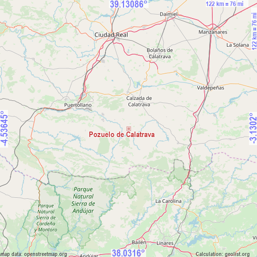
Pozuelo de Calatrava GPS coordinates[2]
38° 34' 59.988" North, 3° 49' 59.988" West
| Map corner | latitude | longitude |
|---|---|---|
| Upper-left | 39.13086°, | -4.53645° |
| Center: | 38.58333°, | -3.83333° |
| Lower-right: | 38.0316°, | -3.1302° |
| Map W x H: | 122.2×122.2 km | = 75.9×75.9mi |
| max Lat: | 43.74134° ⇑85.1% North |
| Pozuelo de Calatrava: | 38.58333° |
| min Lat: | ⇓14.9% South 27.64134° |
| min Long | Pozuelo de Cala | max Long |
| -18.00367° | -3.83333° | 4.2899° |
| W 42.7%⇐ | ⇒57.3% E |
Elevation
Elevation of Pozuelo de Calatrava is 648 m = 2126 ft, and this is 50 m = 164 ft above average elevation for this country.
| Max E: |
1682 m = 5518 ft | 51% |
| Pozuelo de Calatrava | 648 m 2126 ft | |
| Avg. | 598 m = 1962 ft | |
Min E: |
0 m = 0 ft | 49% |
See also: Spain elevation on elevation.city.
Geographical zone
Pozuelo de Calatrava is located in North temperate zone (between Tropic of Cancer and the Arctic Circle). Distance of this Northern Tropic circle is 1684.1 km =1046.5 mi to South.| Distance of | km | miles | from Pozuelo de Calatrava |
|---|---|---|---|
| North Pole | 5717 | 3552.4 | to North |
| Arctic Circle | 3111.1 | 1933.1 | to North |
| Tropic Cancer | 1684.1 | 1046.5 | to South |
| Equator | 4290.1 | 2665.7 | to South |


Nearby cities:
15 places around Pozuelo de Calatrava: (largest is in red/bold)
• Aldea del Rey
17.2 km =10.7 mi,  358°
358°
• Almuradiel
30.2 km =18.8 mi,  104°
104°
• Argamasilla de Calatrava
26.7 km =16.6 mi,  307°
307°
• Ballesteros de Calatrava
29.6 km =18.4 mi,  340°
340°
• Cabezarrubias del Puerto
30.7 km =19.1 mi,  276°
276°
• Granátula de Calatrava
25 km =15.5 mi,  18°
18°
• Hinojosas de Calatrava
26.9 km =16.7 mi, 277°
• La Calzada de Calatrava
14.3 km =8.9 mi, 20°
• Mestanza
20.7 km =12.9 mi,  267°
267°
• Puertollano
26.4 km =16.4 mi,  295°
295°
• San Lorenzo de Calatrava
11.9 km =7.4 mi,  176°
176°
• Valenzuela de Calatrava
30.4 km =18.9 mi,  10°
10°
• Villanueva de San Carlos
7.8 km =4.8 mi, 302°
• Villar del Pozo
31.8 km =19.8 mi, 339°
• Viso del Marqués
24.4 km =15.2 mi,  106°
106°
Sources, notices
• [Note1] Compared only with cities in Spain existing in our database
• [Src1] Map data: © OpenStreetMap contributors (CC-BY-SA)
• [Src2] Other city data from geonames.org with taken over terms of usage.
• [Src3] Geographical zone / Annual Mean Temperature by Robert A. Rohde @ Wikipedia
