Aldea del Rey geodata
Aldea del Rey (Castille-La Mancha) is a seat of a third-order administrative division; located in Spain in Europe/Madrid (GMT+2) time zone. With population of 2,024 people, there are 2153 cities with bigger population in this country. Compared to other cities in Spain, 83.8% of cities are located further ↑North; 57.4% of cities are located further →East and 50.9% of cities have lower elevation than Aldea del Rey. Note1
Administrative division(s):
- Level 1: Castille-La Mancha
- Level 2: Provincia de Ciudad Real
- Level 3: Aldea del Rey


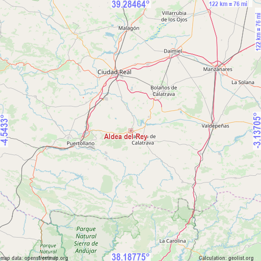
Aldea del Rey GPS coordinates[2]
38° 44' 17.88" North, 3° 50' 24.612" West
| Map corner | latitude | longitude |
|---|---|---|
| Upper-left | 39.28464°, | -4.5433° |
| Center: | 38.7383°, | -3.84017° |
| Lower-right: | 38.18775°, | -3.13705° |
| Map W x H: | 122×122 km | = 75.8×75.8mi |
| max Lat: | 43.74134° ⇑83.8% North |
| Aldea del Rey: | 38.7383° |
| min Lat: | ⇓16.2% South 27.64134° |
| min Long | Aldea del Rey | max Long |
| -18.00367° | -3.84017° | 4.2899° |
| W 42.6%⇐ | ⇒57.4% E |
Elevation
Elevation of Aldea del Rey is 668 m = 2192 ft, and this is 70 m = 230 ft above average elevation for this country.
| Max E: |
1682 m = 5518 ft | 49.1% |
| Aldea del Rey | 668 m 2192 ft | |
| Avg. | 598 m = 1962 ft | |
Min E: |
0 m = 0 ft | 50.9% |
See also: Spain elevation on elevation.city.
Geographical zone
Aldea del Rey is located in North temperate zone (between Tropic of Cancer and the Arctic Circle). Distance of this Northern Tropic circle is 1701.4 km =1057.2 mi to South.| Distance of | km | miles | from Aldea del Rey |
|---|---|---|---|
| North Pole | 5699.8 | 3541.7 | to North |
| Arctic Circle | 3093.9 | 1922.5 | to North |
| Tropic Cancer | 1701.4 | 1057.2 | to South |
| Equator | 4307.3 | 2676.4 | to South |


Nearby cities:
15 places around Aldea del Rey: (largest is in red/bold)
• Almagro
20.2 km =12.6 mi,  33°
33°
• Argamasilla de Calatrava
20.5 km =12.7 mi,  267°
267°
• Ballesteros de Calatrava
14 km =8.7 mi,  319°
319°
• Bolaños de Calatrava
24.2 km =15 mi,  39°
39°
• Cañada de Calatrava
20.3 km =12.6 mi,  309°
309°
• Corral de Calatrava
24.8 km =15.4 mi,  302°
302°
• Granátula de Calatrava
10.6 km =6.6 mi,  52°
52°
• La Calzada de Calatrava
6.8 km =4.2 mi,  124°
124°
• Moral de Calatrava
24.9 km =15.5 mi,  65°
65°
• Poblete
25.1 km =15.6 mi,  330°
330°
• Pozuelo de Calatrava
17.2 km =10.7 mi,  178°
178°
• Puertollano
23.9 km =14.9 mi,  256°
256°
• Valenzuela de Calatrava
14 km =8.7 mi,  24°
24°
• Villanueva de San Carlos
14.3 km =8.9 mi,  204°
204°
• Villar del Pozo
16.4 km =10.2 mi, 319°
Sources, notices
• [Note1] Compared only with cities in Spain existing in our database
• [Src1] Map data: © OpenStreetMap contributors (CC-BY-SA)
• [Src2] Other city data from geonames.org with taken over terms of usage.
• [Src3] Geographical zone / Annual Mean Temperature by Robert A. Rohde @ Wikipedia
