Viso del Marqués geodata
Viso del Marqués (Castille-La Mancha) is a seat of a third-order administrative division; located in Spain in Europe/Madrid (GMT+2) time zone. With population of 2,946 people, there are 1742 cities with bigger population in this country. Compared to other cities in Spain, 85.5% of cities are located further ↑North; 53.1% of cities are located further →East and 65.8% of cities have lower elevation than Viso del Marqués. Note1
Administrative division(s):
- Level 1: Castille-La Mancha
- Level 2: Provincia de Ciudad Real
- Level 3: Viso del Marqués


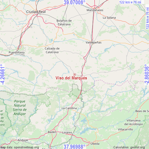
Viso del Marqués GPS coordinates[2]
38° 31' 19.488" North, 3° 33' 48.528" West
| Map corner | latitude | longitude |
|---|---|---|
| Upper-left | 39.07008°, | -4.26661° |
| Center: | 38.52208°, | -3.56348° |
| Lower-right: | 37.96988°, | -2.86036° |
| Map W x H: | 122.3×122.3 km | = 76×76mi |
| max Lat: | 43.74134° ⇑85.5% North |
| Viso del Marqués: | 38.52208° |
| min Lat: | ⇓14.5% South 27.64134° |
| min Long | Viso del Marqu� | max Long |
| -18.00367° | -3.56348° | 4.2899° |
| W 46.9%⇐ | ⇒53.1% E |
Elevation
Elevation of Viso del Marqués is 783 m = 2569 ft, and this is 185 m = 607 ft above average elevation for this country.
| Max E: |
1682 m = 5518 ft | 34.2% |
| Viso del Marqués | 783 m 2569 ft | |
| Avg. | 598 m = 1962 ft | |
Min E: |
0 m = 0 ft | 65.8% |
See also: Spain elevation on elevation.city.
Geographical zone
Viso del Marqués is located in North temperate zone (between Tropic of Cancer and the Arctic Circle). Distance of this Northern Tropic circle is 1677.3 km =1042.2 mi to South.| Distance of | km | miles | from Viso del Marqués |
|---|---|---|---|
| North Pole | 5723.8 | 3556.6 | to North |
| Arctic Circle | 3117.9 | 1937.4 | to North |
| Tropic Cancer | 1677.3 | 1042.2 | to South |
| Equator | 4283.3 | 2661.5 | to South |


Nearby cities:
15 places around Viso del Marqués: (largest is in red/bold)
• Aldea del Rey
34 km =21.1 mi,  315°
315°
• Aldeaquemada
20.7 km =12.9 mi,  126°
126°
• Almuradiel
5.8 km =3.6 mi,  99°
99°
• Carboneros
33.1 km =20.6 mi,  190°
190°
• Castellar de Santiago
25.1 km =15.6 mi,  85°
85°
• La Calzada de Calatrava
27.3 km =17 mi, 317°
• La Carolina
27.8 km =17.3 mi, 189°
• Moral de Calatrava
34.2 km =21.3 mi,  357°
357°
• Pozuelo de Calatrava
24.4 km =15.2 mi,  286°
286°
• San Lorenzo de Calatrava
23.4 km =14.5 mi,  257°
257°
• Santa Cruz de Mudela
15.8 km =9.8 mi,  32°
32°
• Santa Elena
20.2 km =12.6 mi,  174°
174°
• Torrenueva
21.8 km =13.5 mi,  53°
53°
• Valdepeñas
30.9 km =19.2 mi, 30°
• Villanueva de San Carlos
32 km =19.9 mi, 290°
Sources, notices
• [Note1] Compared only with cities in Spain existing in our database
• [Src1] Map data: © OpenStreetMap contributors (CC-BY-SA)
• [Src2] Other city data from geonames.org with taken over terms of usage.
• [Src3] Geographical zone / Annual Mean Temperature by Robert A. Rohde @ Wikipedia
