Pinet geodata
Pinet (Valencia) is a seat of a third-order administrative division; located in Spain in Europe/Madrid (GMT+2) time zone. With population of 192 people, there are 5092 cities with bigger population in this country. Compared to other cities in Spain, 81.1% of cities are located further ↑North; 84.1% of cities are located further ←West and 72.2% of cities have higher elevation than Pinet. Note1


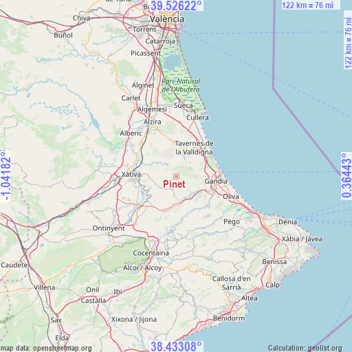
Pinet GPS coordinates[2]
38° 58' 54.336" North, 0° 20' 19.32" West
| Map corner | latitude | longitude |
|---|---|---|
| Upper-left | 39.52622°, | -1.04182° |
| Center: | 38.98176°, | -0.3387° |
| Lower-right: | 38.43308°, | 0.36443° |
| Map W x H: | 121.5×121.5 km | = 75.5×75.5mi |
| max Lat: | 43.74134° ⇑81.1% North |
| Pinet: | 38.98176° |
| min Lat: | ⇓18.9% South 27.64134° |
| min Long | Pinet | max Long |
| -18.00367° | -0.3387° | 4.2899° |
| W 84.1%⇐ | ⇒15.9% E |
Elevation
Elevation of Pinet is 343 m = 1125 ft, and this is 255 m = 837 ft below average elevation for this country.
| Max E: |
1682 m = 5518 ft | 72.2% |
| Avg. | 598 m = 1962 ft | |
| Pinet | 343 m = 1125 ft | |
Min E: |
0 m = 0 ft | 27.8% |
See also: Spain elevation on elevation.city.
Geographical zone
Pinet is located in North temperate zone (between Tropic of Cancer and the Arctic Circle). Distance of this Northern Tropic circle is 1728.4 km =1074 mi to South.| Distance of | km | miles | from Pinet |
|---|---|---|---|
| North Pole | 5672.7 | 3524.9 | to North |
| Arctic Circle | 3066.8 | 1905.6 | to North |
| Tropic Cancer | 1728.4 | 1074 | to South |
| Equator | 4334.4 | 2693.3 | to South |


Nearby cities:
15 places around Pinet: (largest is in red/bold)
• Alfauir
9.4 km =5.8 mi,  125°
125°
• Almiserà
8.7 km =5.4 mi,  146°
146°
• Barx
5.1 km =3.2 mi,  40°
40°
• Barxeta
7.8 km =4.8 mi,  299°
299°
• Benicolet
6.9 km =4.3 mi,  185°
185°
• Benigànim
8.9 km =5.5 mi,  246°
246°
• Castellonet de la Conquesta
9.5 km =5.9 mi,  139°
139°
• Llocnou de Sant Jeroni
8.7 km =5.4 mi, 146°
• Llutxent
5.5 km =3.4 mi, 190°
• Montichelvo
10.1 km =6.3 mi,  181°
181°
• Quatretonda
6.4 km =4 mi,  236°
236°
• Rótova
8.9 km =5.5 mi, 128°
• Simat de la Valldigna
6 km =3.7 mi,  18°
18°
• Terrateig
9.8 km =6.1 mi,  170°
170°
• Xeresa
11.2 km =7 mi,  69°
69°
Sources, notices
• [Note1] Compared only with cities in Spain existing in our database
• [Src1] Map data: © OpenStreetMap contributors (CC-BY-SA)
• [Src2] Other city data from geonames.org with taken over terms of usage.
• [Src3] Geographical zone / Annual Mean Temperature by Robert A. Rohde @ Wikipedia
