Benicolet geodata
Benicolet (Valencia) is a seat of a third-order administrative division; located in Spain in Europe/Madrid (GMT+2) time zone. With population of 517 people, there are 3825 cities with bigger population in this country. Compared to other cities in Spain, 81.9% of cities are located further ↑North; 84% of cities are located further ←West and 79% of cities have higher elevation than Benicolet. Note1


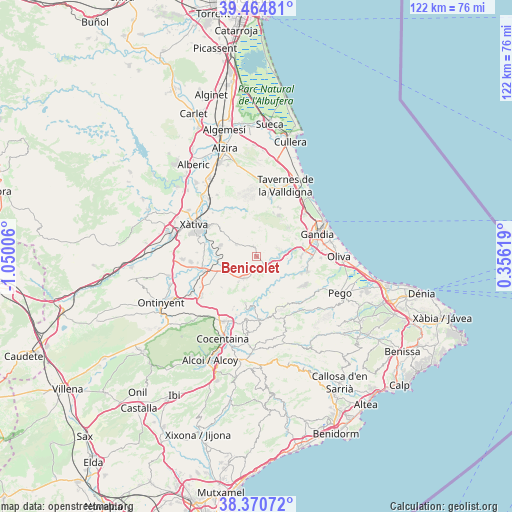
Benicolet GPS coordinates[2]
38° 55' 11.532" North, 0° 20' 48.984" West
| Map corner | latitude | longitude |
|---|---|---|
| Upper-left | 39.46481°, | -1.05006° |
| Center: | 38.91987°, | -0.34694° |
| Lower-right: | 38.37072°, | 0.35619° |
| Map W x H: | 121.7×121.7 km | = 75.6×75.6mi |
| max Lat: | 43.74134° ⇑81.9% North |
| Benicolet: | 38.91987° |
| min Lat: | ⇓18.1% South 27.64134° |
| min Long | Benicolet | max Long |
| -18.00367° | -0.34694° | 4.2899° |
| W 84%⇐ | ⇒16% E |
Elevation
Elevation of Benicolet is 238 m = 781 ft, and this is 360 m = 1181 ft below average elevation for this country.
| Max E: |
1682 m = 5518 ft | 79% |
| Avg. | 598 m = 1962 ft | |
| Benicolet | 238 m = 781 ft | |
Min E: |
0 m = 0 ft | 21% |
See also: Spain elevation on elevation.city.
Geographical zone
Benicolet is located in North temperate zone (between Tropic of Cancer and the Arctic Circle). Distance of this Northern Tropic circle is 1721.6 km =1069.8 mi to South.| Distance of | km | miles | from Benicolet |
|---|---|---|---|
| North Pole | 5679.6 | 3529.1 | to North |
| Arctic Circle | 3073.7 | 1909.9 | to North |
| Tropic Cancer | 1721.6 | 1069.8 | to South |
| Equator | 4327.5 | 2689 | to South |


Nearby cities:
15 places around Benicolet: (largest is in red/bold)
• Alfauir
8.5 km =5.3 mi,  79°
79°
• Almiserà
5.5 km =3.4 mi,  93°
93°
• Beniatjar
10.1 km =6.3 mi,  217°
217°
• Benigànim
8.2 km =5.1 mi,  294°
294°
• Castellonet de la Conquesta
7 km =4.3 mi, 92°
• Castelló de Rugat
4.4 km =2.7 mi,  202°
202°
• Llocnou de Sant Jeroni
5.5 km =3.4 mi, 93°
• Llutxent
1.5 km =0.9 mi,  349°
349°
• Montichelvo
3.2 km =2 mi,  171°
171°
• Pinet
6.9 km =4.3 mi,  5°
5°
• Quatretonda
5.7 km =3.5 mi,  306°
306°
• Rugat
4.7 km =2.9 mi, 195°
• Ráfol de Salem
7.5 km =4.7 mi, 217°
• Rótova
7.8 km =4.8 mi, 80°
• Terrateig
3.7 km =2.3 mi,  140°
140°
Sources, notices
• [Note1] Compared only with cities in Spain existing in our database
• [Src1] Map data: © OpenStreetMap contributors (CC-BY-SA)
• [Src2] Other city data from geonames.org with taken over terms of usage.
• [Src3] Geographical zone / Annual Mean Temperature by Robert A. Rohde @ Wikipedia
