Castellonet de la Conquesta geodata
Castellonet de la Conquesta (Valencia) is a seat of a third-order administrative division; located in Spain in Europe/Madrid (GMT+2) time zone. With population of 172 people, there are 5251 cities with bigger population in this country. Compared to other cities in Spain, 82% of cities are located further ↑North; 84.9% of cities are located further ←West and 81.5% of cities have higher elevation than Castellonet de la Conquesta. Note1
Administrative division(s):
- Level 1: Valencia
- Level 2: Província de València
- Level 3: Castellonet de la Conquesta
Current local time in Castellonet de la Conquesta:
10:40 PM, ThursdayDifference from your time zone: hours


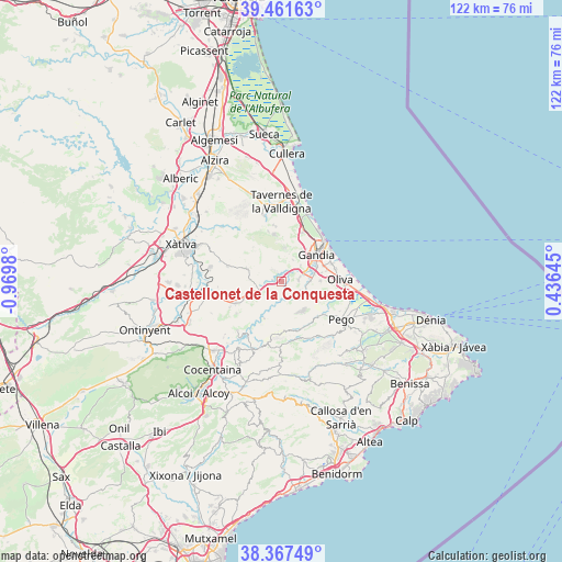
Castellonet de la Conquesta GPS coordinates[2]
38° 55' 0.012" North, 0° 16' 0.012" West
| Map corner | latitude | longitude |
|---|---|---|
| Upper-left | 39.46163°, | -0.9698° |
| Center: | 38.91667°, | -0.26667° |
| Lower-right: | 38.36749°, | 0.43645° |
| Map W x H: | 121.7×121.7 km | = 75.6×75.6mi |
| max Lat: | 43.74134° ⇑82% North |
| Castellonet de la Conquesta: | 38.91667° |
| min Lat: | ⇓18% South 27.64134° |
| min Long | Castellonet de | max Long |
| -18.00367° | -0.26667° | 4.2899° |
| W 84.9%⇐ | ⇒15.1% E |
Elevation
Elevation of Castellonet de la Conquesta is 196 m = 643 ft, and this is 402 m = 1319 ft below average elevation for this country.
| Max E: |
1682 m = 5518 ft | 81.5% |
| Avg. | 598 m = 1962 ft | |
| Castellonet de la Conquesta | 196 m = 643 ft | |
Min E: |
0 m = 0 ft | 18.5% |
See also: Spain elevation on elevation.city.
Geographical zone
Castellonet de la Conquesta is located in North temperate zone (between Tropic of Cancer and the Arctic Circle). Distance of this Northern Tropic circle is 1721.2 km =1069.5 mi to South.| Distance of | km | miles | from Castellonet de la Conquesta |
|---|---|---|---|
| North Pole | 5679.9 | 3529.3 | to North |
| Arctic Circle | 3074 | 1910.1 | to North |
| Tropic Cancer | 1721.2 | 1069.5 | to South |
| Equator | 4327.1 | 2688.7 | to South |


Nearby cities:
15 places around Castellonet de la Conquesta: (largest is in red/bold)
• Ador
3.8 km =2.4 mi,  87°
87°
• Alfauir
2.3 km =1.4 mi,  37°
37°
• Almiserà
1.4 km =0.9 mi,  270°
270°
• Beniarjó
7.2 km =4.5 mi,  75°
75°
• Benicolet
7 km =4.3 mi, 272°
• Beniflá
7.8 km =4.8 mi, 80°
• Llocnou de Sant Jeroni
1.4 km =0.9 mi, 270°
• Llutxent
7.4 km =4.6 mi,  284°
284°
• Montichelvo
7 km =4.3 mi,  246°
246°
• Palma de Gandía
4.2 km =2.6 mi,  74°
74°
• Potríes
6.1 km =3.8 mi, 90°
• Real de Gandía
7.3 km =4.5 mi,  61°
61°
• Rótova
1.9 km =1.2 mi,  24°
24°
• Terrateig
5.2 km =3.2 mi,  241°
241°
• Villalonga
6.1 km =3.8 mi,  124°
124°
Sources, notices
• [Note1] Compared only with cities in Spain existing in our database
• [Src1] Map data: © OpenStreetMap contributors (CC-BY-SA)
• [Src2] Other city data from geonames.org with taken over terms of usage.
• [Src3] Geographical zone / Annual Mean Temperature by Robert A. Rohde @ Wikipedia
