Montichelvo geodata
Montichelvo (Valencia) is a seat of a third-order administrative division; located in Spain in Europe/Madrid (GMT+2) time zone. With population of 673 people, there are 3454 cities with bigger population in this country. Compared to other cities in Spain, 82.2% of cities are located further ↑North; 84.1% of cities are located further ←West and 76.9% of cities have higher elevation than Montichelvo. Note1
Administrative division(s):
- Level 1: Valencia
- Level 2: Província de València
- Level 3: Montitxelvo/Montichelvo


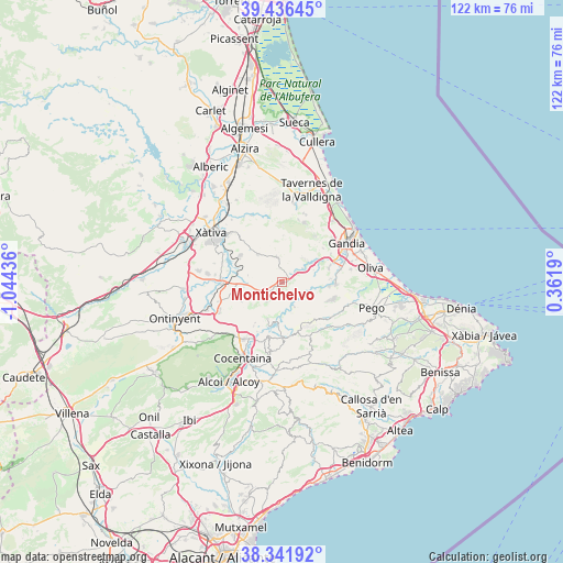
Montichelvo GPS coordinates[2]
38° 53' 28.644" North, 0° 20' 28.428" West
| Map corner | latitude | longitude |
|---|---|---|
| Upper-left | 39.43645°, | -1.04436° |
| Center: | 38.89129°, | -0.34123° |
| Lower-right: | 38.34192°, | 0.3619° |
| Map W x H: | 121.7×121.7 km | = 75.6×75.6mi |
| max Lat: | 43.74134° ⇑82.2% North |
| Montichelvo: | 38.89129° |
| min Lat: | ⇓17.8% South 27.64134° |
| min Long | Montichelvo | max Long |
| -18.00367° | -0.34123° | 4.2899° |
| W 84.1%⇐ | ⇒15.9% E |
Elevation
Elevation of Montichelvo is 272 m = 892 ft, and this is 326 m = 1070 ft below average elevation for this country.
| Max E: |
1682 m = 5518 ft | 76.9% |
| Avg. | 598 m = 1962 ft | |
| Montichelvo | 272 m = 892 ft | |
Min E: |
0 m = 0 ft | 23.1% |
See also: Spain elevation on elevation.city.
Geographical zone
Montichelvo is located in North temperate zone (between Tropic of Cancer and the Arctic Circle). Distance of this Northern Tropic circle is 1718.4 km =1067.8 mi to South.| Distance of | km | miles | from Montichelvo |
|---|---|---|---|
| North Pole | 5682.8 | 3531.1 | to North |
| Arctic Circle | 3076.9 | 1911.9 | to North |
| Tropic Cancer | 1718.4 | 1067.8 | to South |
| Equator | 4324.3 | 2687 | to South |


Nearby cities:
15 places around Montichelvo: (largest is in red/bold)
• Alfauir
9.2 km =5.7 mi,  59°
59°
• Almiserà
5.8 km =3.6 mi, 60°
• Beniarrés
8.5 km =5.3 mi,  201°
201°
• Beniatjar
8.2 km =5.1 mi,  233°
233°
• Benicolet
3.2 km =2 mi,  351°
351°
• Castellonet de la Conquesta
7 km =4.3 mi,  66°
66°
• Castelló de Rugat
2.4 km =1.5 mi,  248°
248°
• Llocnou de Sant Jeroni
5.8 km =3.6 mi, 60°
• Llutxent
4.7 km =2.9 mi, 350°
• Otos
9.8 km =6.1 mi, 245°
• Quatretonda
8.3 km =5.2 mi,  322°
322°
• Rugat
2.2 km =1.4 mi, 232°
• Ráfol de Salem
5.8 km =3.6 mi,  241°
241°
• Rótova
8.5 km =5.3 mi, 57°
• Terrateig
1.9 km =1.2 mi,  78°
78°
Sources, notices
• [Note1] Compared only with cities in Spain existing in our database
• [Src1] Map data: © OpenStreetMap contributors (CC-BY-SA)
• [Src2] Other city data from geonames.org with taken over terms of usage.
• [Src3] Geographical zone / Annual Mean Temperature by Robert A. Rohde @ Wikipedia
