Pájara geodata
Pájara (Canary Islands) is a seat of a third-order administrative division; located in Spain in Atlantic/Canary (GMT+1) time zone. With population of 20,821 people, there are 460 cities with bigger population in this country. Compared to other cities in Spain, 99.2% of cities are located further ↑North; 98.7% of cities are located further →East and 80.4% of cities have higher elevation than Pájara. Note1
Administrative division(s):
- Level 1: Canary Islands
- Level 2: Provincia de Las Palmas
- Level 3: Pájara


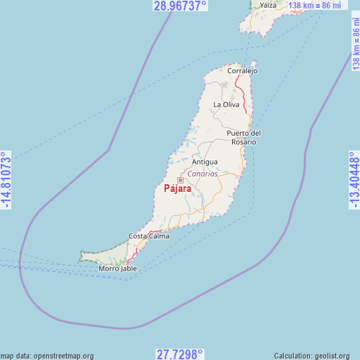
Pájara GPS coordinates[2]
28° 21' 1.404" North, 14° 6' 27.36" West
| Map corner | latitude | longitude |
|---|---|---|
| Upper-left | 28.96737°, | -14.81073° |
| Center: | 28.35039°, | -14.1076° |
| Lower-right: | 27.7298°, | -13.40448° |
| Map W x H: | 137.6×137.6 km | = 85.5×85.5mi |
| max Lat: | 43.74134° ⇑99.2% North |
| Pájara: | 28.35039° |
| min Lat: | ⇓0.8% South 27.64134° |
| min Long | Pájara | max Long |
| -18.00367° | -14.1076° | 4.2899° |
| W 1.3%⇐ | ⇒98.7% E |
Elevation
Elevation of Pájara is 213 m = 699 ft, and this is 385 m = 1263 ft below average elevation for this country.
| Max E: |
1682 m = 5518 ft | 80.4% |
| Avg. | 598 m = 1962 ft | |
| Pájara | 213 m = 699 ft | |
Min E: |
0 m = 0 ft | 19.6% |
See also: Spain elevation on elevation.city.
Geographical zone
Pájara is located in North temperate zone (between Tropic of Cancer and the Arctic Circle). Distance of this Northern Tropic circle is 546.3 km =339.5 mi to South.| Distance of | km | miles | from Pájara |
|---|---|---|---|
| North Pole | 6854.8 | 4259.4 | to North |
| Arctic Circle | 4248.9 | 2640.1 | to North |
| Tropic Cancer | 546.3 | 339.5 | to South |
| Equator | 3152.3 | 1958.7 | to South |


Nearby cities:
15 places around Pájara: (largest is in red/bold)
• Antigua
12.2 km =7.6 mi,  48°
48°
• Betancuría
9.6 km =6 mi,  32°
32°
• Corralejo
48.4 km =30.1 mi, 29°
• Costa Calma
24 km =14.9 mi,  209°
209°
• El Cotillo
38.2 km =23.7 mi,  14°
14°
• La Oliva
33.8 km =21 mi, 31°
• Mácher
77.9 km =48.4 mi, 31°
• Playa Blanca
63.3 km =39.3 mi, 25°
• Puerto del Carmen
76.9 km =47.8 mi, 34°
• Puerto del Rosario
29.2 km =18.1 mi,  55°
55°
• San Bartolomé
86.9 km =54 mi, 33°
• Tuineje
6.6 km =4.1 mi,  116°
116°
• Tías
81.5 km =50.6 mi, 33°
• Uga
75.5 km =46.9 mi, 27°
• Yaiza
75.2 km =46.7 mi, 26°
Sources, notices
• [Note1] Compared only with cities in Spain existing in our database
• [Src1] Map data: © OpenStreetMap contributors (CC-BY-SA)
• [Src2] Other city data from geonames.org with taken over terms of usage.
• [Src3] Geographical zone / Annual Mean Temperature by Robert A. Rohde @ Wikipedia
