Montillana geodata
Montillana (Andalusia) is a seat of a third-order administrative division; located in Spain in Europe/Madrid (GMT+2) time zone. With population of 1,300 people, there are 2645 cities with bigger population in this country. Compared to other cities in Spain, 91.3% of cities are located further ↑North; 54.9% of cities are located further →East and 89.4% of cities have lower elevation than Montillana. Note1


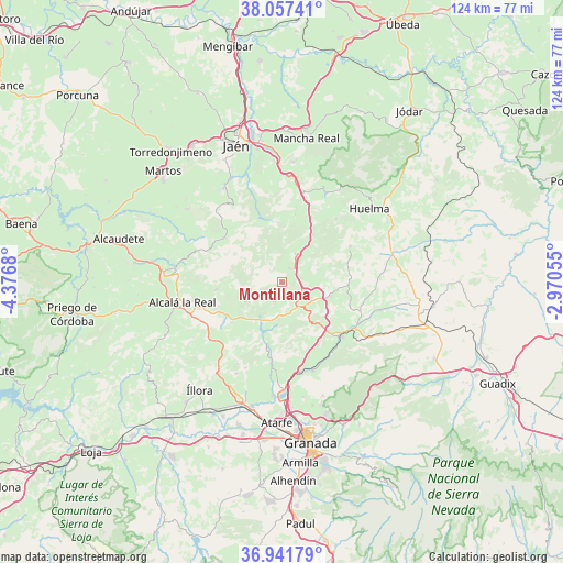
Montillana GPS coordinates[2]
37° 30' 6.048" North, 3° 40' 25.248" West
| Map corner | latitude | longitude |
|---|---|---|
| Upper-left | 38.05741°, | -4.3768° |
| Center: | 37.50168°, | -3.67368° |
| Lower-right: | 36.94179°, | -2.97055° |
| Map W x H: | 124×124 km | = 77.1×77.1mi |
| max Lat: | 43.74134° ⇑91.3% North |
| Montillana: | 37.50168° |
| min Lat: | ⇓8.7% South 27.64134° |
| min Long | Montillana | max Long |
| -18.00367° | -3.67368° | 4.2899° |
| W 45.1%⇐ | ⇒54.9% E |
Elevation
Elevation of Montillana is 1021 m = 3350 ft, and this is 423 m = 1388 ft above average elevation for this country.
| Max E: |
1682 m = 5518 ft | 10.6% |
| Montillana | 1021 m 3350 ft | |
| Avg. | 598 m = 1962 ft | |
Min E: |
0 m = 0 ft | 89.4% |
See also: Spain elevation on elevation.city.
Geographical zone
Montillana is located in North temperate zone (between Tropic of Cancer and the Arctic Circle). Distance of this Northern Tropic circle is 1563.9 km =971.8 mi to South.| Distance of | km | miles | from Montillana |
|---|---|---|---|
| North Pole | 5837.3 | 3627.1 | to North |
| Arctic Circle | 3231.4 | 2007.9 | to North |
| Tropic Cancer | 1563.9 | 971.8 | to South |
| Equator | 4169.8 | 2591 | to South |


Nearby cities:
15 places around Montillana: (largest is in red/bold)
• Benalúa de las Villas
8.3 km =5.2 mi,  185°
185°
• Cambil
21.9 km =13.6 mi,  25°
25°
• Campillo de Arenas
6.9 km =4.3 mi, 29°
• Campotéjar
5.4 km =3.4 mi,  113°
113°
• Colomera
14.9 km =9.3 mi, 193°
• Dehesas Viejas
11.1 km =6.9 mi, 105°
• Deifontes
20.7 km =12.9 mi,  160°
160°
• Domingo Pérez
14.5 km =9 mi,  92°
92°
• Frailes
14.5 km =9 mi,  263°
263°
• Iznalloz
17.7 km =11 mi,  133°
133°
• Moclín
20.6 km =12.8 mi,  208°
208°
• Montejicar
16.8 km =10.4 mi,  62°
62°
• Noalejo
3.5 km =2.2 mi, 26°
• Piñar
21.7 km =13.5 mi, 107°
• Valdepeñas de Jaén
15.8 km =9.8 mi,  308°
308°
Sources, notices
• [Note1] Compared only with cities in Spain existing in our database
• [Src1] Map data: © OpenStreetMap contributors (CC-BY-SA)
• [Src2] Other city data from geonames.org with taken over terms of usage.
• [Src3] Geographical zone / Annual Mean Temperature by Robert A. Rohde @ Wikipedia
