Piñar geodata
Piñar (Andalusia) is a populated place; located in Spain in Europe/Madrid (GMT+2) time zone. With population of 1,110 people, there are 2814 cities with bigger population in this country. Compared to other cities in Spain, 91.6% of cities are located further ↑North; 51.3% of cities are located further →East and 80.5% of cities have lower elevation than Piñar. Note1


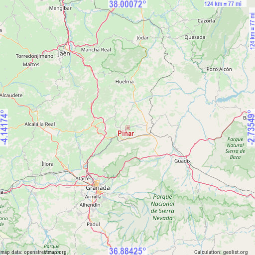
Piñar GPS coordinates[2]
37° 26' 40.452" North, 3° 26' 18.996" West
| Map corner | latitude | longitude |
|---|---|---|
| Upper-left | 38.00072°, | -4.14174° |
| Center: | 37.44457°, | -3.43861° |
| Lower-right: | 36.88425°, | -2.73549° |
| Map W x H: | 124.1×124.1 km | = 77.1×77.1mi |
| max Lat: | 43.74134° ⇑91.6% North |
| Piñar: | 37.44457° |
| min Lat: | ⇓8.4% South 27.64134° |
| min Long | Piñar | max Long |
| -18.00367° | -3.43861° | 4.2899° |
| W 48.7%⇐ | ⇒51.3% E |
Elevation
Elevation of Piñar is 902 m = 2959 ft, and this is 304 m = 997 ft above average elevation for this country.
| Max E: |
1682 m = 5518 ft | 19.5% |
| Piñar | 902 m 2959 ft | |
| Avg. | 598 m = 1962 ft | |
Min E: |
0 m = 0 ft | 80.5% |
See also: Spain elevation on elevation.city.
Geographical zone
Piñar is located in North temperate zone (between Tropic of Cancer and the Arctic Circle). Distance of this Northern Tropic circle is 1557.5 km =967.8 mi to South.| Distance of | km | miles | from Piñar |
|---|---|---|---|
| North Pole | 5843.6 | 3631 | to North |
| Arctic Circle | 3237.7 | 2011.8 | to North |
| Tropic Cancer | 1557.5 | 967.8 | to South |
| Equator | 4163.4 | 2587 | to South |


Nearby cities:
15 places around Piñar: (largest is in red/bold)
• Campillo de Arenas
21.3 km =13.2 mi,  305°
305°
• Campotéjar
16.4 km =10.2 mi,  284°
284°
• Darro
16.5 km =10.3 mi,  129°
129°
• Dehesas Viejas
10.6 km =6.6 mi,  288°
288°
• Deifontes
19.1 km =11.9 mi,  226°
226°
• Diezma
16.7 km =10.4 mi,  145°
145°
• Domingo Pérez
8.5 km =5.3 mi, 312°
• Gobernador
11 km =6.8 mi,  70°
70°
• Guadahortuna
13 km =8.1 mi,  15°
15°
• Huélago
15.8 km =9.8 mi,  100°
100°
• Iznalloz
9.8 km =6.1 mi, 233°
• Montejicar
15.4 km =9.6 mi,  337°
337°
• Noalejo
21.4 km =13.3 mi,  296°
296°
• Pedro Martínez
19.4 km =12.1 mi, 70°
• Torre-Cardela
9.9 km =6.2 mi,  47°
47°
Sources, notices
• [Note1] Compared only with cities in Spain existing in our database
• [Src1] Map data: © OpenStreetMap contributors (CC-BY-SA)
• [Src2] Other city data from geonames.org with taken over terms of usage.
• [Src3] Geographical zone / Annual Mean Temperature by Robert A. Rohde @ Wikipedia
