Mira geodata
Mira (Castille-La Mancha) is a seat of a third-order administrative division; located in Spain in Europe/Madrid (GMT+2) time zone. With population of 1,208 people, there are 2719 cities with bigger population in this country. Compared to other cities in Spain, 74.1% of cities are located further ↑North; 73.6% of cities are located further ←West and 76.3% of cities have lower elevation than Mira. Note1


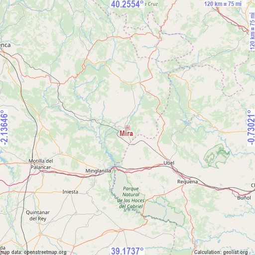
Mira GPS coordinates[2]
39° 43' 0.012" North, 1° 25' 59.988" West
| Map corner | latitude | longitude |
|---|---|---|
| Upper-left | 40.2554°, | -2.13646° |
| Center: | 39.71667°, | -1.43333° |
| Lower-right: | 39.1737°, | -0.73021° |
| Map W x H: | 120.3×120.3 km | = 74.8×74.8mi |
| max Lat: | 43.74134° ⇑74.1% North |
| Mira: | 39.71667° |
| min Lat: | ⇓25.9% South 27.64134° |
| min Long | Mira | max Long |
| -18.00367° | -1.43333° | 4.2899° |
| W 73.6%⇐ | ⇒26.4% E |
Elevation
Elevation of Mira is 862 m = 2828 ft, and this is 264 m = 866 ft above average elevation for this country.
| Max E: |
1682 m = 5518 ft | 23.7% |
| Mira | 862 m 2828 ft | |
| Avg. | 598 m = 1962 ft | |
Min E: |
0 m = 0 ft | 76.3% |
See also: Spain elevation on elevation.city.
Geographical zone
Mira is located in North temperate zone (between Tropic of Cancer and the Arctic Circle). Distance of this Northern Tropic circle is 1810.2 km =1124.8 mi to South.| Distance of | km | miles | from Mira |
|---|---|---|---|
| North Pole | 5591 | 3474.1 | to North |
| Arctic Circle | 2985.1 | 1854.9 | to North |
| Tropic Cancer | 1810.2 | 1124.8 | to South |
| Equator | 4416.1 | 2744 | to South |


Nearby cities:
15 places around Mira: (largest is in red/bold)
• Aliaguilla
9.6 km =6 mi,  73°
73°
• Camporrobles
7.9 km =4.9 mi,  158°
158°
• Cardenete
22.1 km =13.7 mi,  284°
284°
• Caudete de las Fuentes
21.9 km =13.6 mi,  142°
142°
• Enguídanos
15.3 km =9.5 mi,  248°
248°
• Fuentelespino de Moya
22.4 km =13.9 mi,  352°
352°
• Fuenterrobles
16.5 km =10.3 mi,  154°
154°
• Garaballa
12.5 km =7.8 mi,  27°
27°
• Henarejos
17.2 km =10.7 mi, 345°
• Landete
21.2 km =13.2 mi,  15°
15°
• Narboneta
4.7 km =2.9 mi,  322°
322°
• San Martín de Boniches
23.4 km =14.5 mi,  330°
330°
• Sinarcas
17.2 km =10.7 mi,  83°
83°
• Talayuelas
19.6 km =12.2 mi,  40°
40°
• Villargordo del Cabriel
20.4 km =12.7 mi,  180°
180°
Sources, notices
• [Note1] Compared only with cities in Spain existing in our database
• [Src1] Map data: © OpenStreetMap contributors (CC-BY-SA)
• [Src2] Other city data from geonames.org with taken over terms of usage.
• [Src3] Geographical zone / Annual Mean Temperature by Robert A. Rohde @ Wikipedia
