Fuenterrobles geodata
Fuenterrobles (Valencia) is a seat of a third-order administrative division; located in Spain in Europe/Madrid (GMT+2) time zone. With population of 737 people, there are 3332 cities with bigger population in this country. Compared to other cities in Spain, 75.9% of cities are located further ↑North; 74.3% of cities are located further ←West and 82.4% of cities have lower elevation than Fuenterrobles. Note1


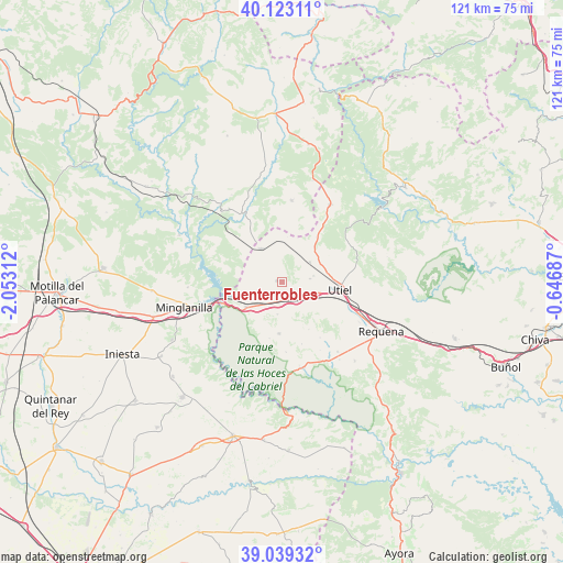
Fuenterrobles GPS coordinates[2]
39° 34' 59.988" North, 1° 21' 0" West
| Map corner | latitude | longitude |
|---|---|---|
| Upper-left | 40.12311°, | -2.05312° |
| Center: | 39.58333°, | -1.35° |
| Lower-right: | 39.03932°, | -0.64687° |
| Map W x H: | 120.5×120.5 km | = 74.9×74.9mi |
| max Lat: | 43.74134° ⇑75.9% North |
| Fuenterrobles: | 39.58333° |
| min Lat: | ⇓24.1% South 27.64134° |
| min Long | Fuenterrobles | max Long |
| -18.00367° | -1.35° | 4.2899° |
| W 74.3%⇐ | ⇒25.7% E |
Elevation
Elevation of Fuenterrobles is 921 m = 3022 ft, and this is 323 m = 1060 ft above average elevation for this country.
| Max E: |
1682 m = 5518 ft | 17.6% |
| Fuenterrobles | 921 m 3022 ft | |
| Avg. | 598 m = 1962 ft | |
Min E: |
0 m = 0 ft | 82.4% |
See also: Spain elevation on elevation.city.
Geographical zone
Fuenterrobles is located in North temperate zone (between Tropic of Cancer and the Arctic Circle). Distance of this Northern Tropic circle is 1795.3 km =1115.5 mi to South.| Distance of | km | miles | from Fuenterrobles |
|---|---|---|---|
| North Pole | 5605.8 | 3483.3 | to North |
| Arctic Circle | 2999.9 | 1864.1 | to North |
| Tropic Cancer | 1795.3 | 1115.5 | to South |
| Equator | 4401.3 | 2734.8 | to South |


Nearby cities:
15 places around Fuenterrobles: (largest is in red/bold)
• Aliaguilla
17.7 km =11 mi,  6°
6°
• Benagéber
26 km =16.2 mi,  55°
55°
• Camporrobles
8.6 km =5.3 mi,  329°
329°
• Caudete de las Fuentes
6.7 km =4.2 mi,  113°
113°
• Enguídanos
23.3 km =14.5 mi,  293°
293°
• Garaballa
26 km =16.2 mi,  356°
356°
• Minglanilla
22.1 km =13.7 mi,  255°
255°
• Mira
16.5 km =10.3 mi, 334°
• Narboneta
21.1 km =13.1 mi, 331°
• Puebla del Salvador
27.2 km =16.9 mi,  266°
266°
• Requena
23.9 km =14.9 mi,  116°
116°
• Sinarcas
19.4 km =12.1 mi,  30°
30°
• Utiel
13 km =8.1 mi,  98°
98°
• Venta del Moro
11.1 km =6.9 mi,  180°
180°
• Villargordo del Cabriel
9.1 km =5.7 mi,  232°
232°
Sources, notices
• [Note1] Compared only with cities in Spain existing in our database
• [Src1] Map data: © OpenStreetMap contributors (CC-BY-SA)
• [Src2] Other city data from geonames.org with taken over terms of usage.
• [Src3] Geographical zone / Annual Mean Temperature by Robert A. Rohde @ Wikipedia
